
Home |
Temáticas |
Catálogos |
Pedidos |
| |
|||||||
|

|
RUGENDAS. (Johann Moritz) HABITANTE DE GOYAS, QUADRO A ÓLEO PINTADO SOBRE MADEIRA. |
|
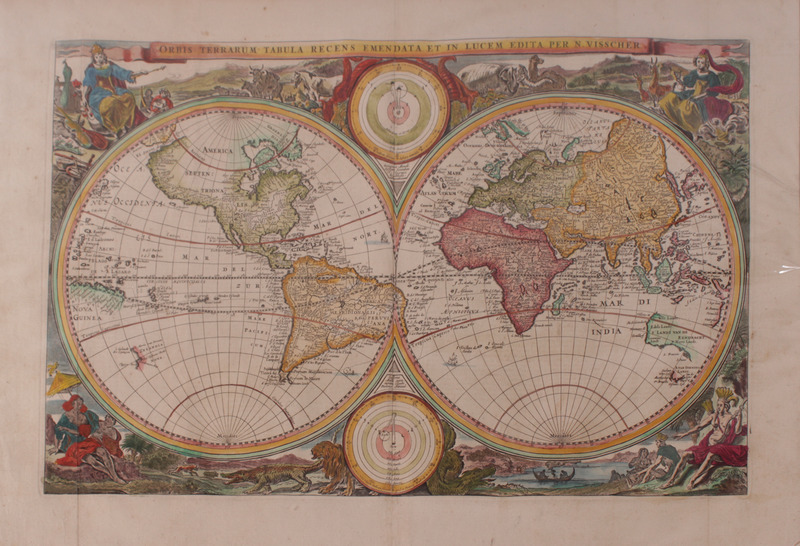
Clique nas imagens para aumentar. VISSCHER. (Nicholas) CARTOGRAFIA - SÉC. XVII - ORBIS TERRARUM TABULAORBIS TERRARUM TABULA RECENS EMENDATA ET IN LUCEM EDITA PER N. VISSCHER. WERELTS, Hoe deselve na de Zuntvloeyt zyn verdeelt en bewoont door de Nakomeligenvan Noah, [..] Circa 1663-1686. De 54x37 cm. Colorido à mão na época. Mapa impresso por Nicolaes Visscher, o primeiro deste nome, gravador e cartógrafo holandês. Este mapa-mundo teve uma versão inicial em 1658. A presente chapa com o presente arranjo gráfico data de cerca de 1663 e foi usada em impressões até 1686. Torna-se possível identificar a edição à qual pertence este exemplar recorrendo à leitura do texto em holandês que se encontra visível no verso. No entanto a data exacta (situada entre 1663 e 1686) ainda não foi determinada pela nossa investigação. O mapa é um exemplo dos mais antigos mapas holandeses decorados com iconografia. Neste caso os deuses do Olimpo, entre os quais Zeus (que representa a Europa com um boi, um cavalo e um carneiro) e Deméter (que aqui representa a Ásia junto a um camelo lanígero da Tartária e a um elefante indiano) que se encontram nos topos direito e esquerdo. Nos cantos inferiores encontram-se as divindades dos povos primitivos descobertos pelos europeus, nomeadamente no canto inferior direito uma potestade africana (com um macaco, um crocodilo e um leão) e no canto inferior esquerdo uma potestade ameríndia (dos índios do Brasil) junto a um grande rio (Amazonas) com uma anaconda. A Austrália apresenta-se delineada na sua costa Noroeste com a ocupação holandesa anterior à ocupação inglesa, nomeadamente: Landt van Eendracht, Wits Landt, Edels Landt, P. Nuyst Landt e Leeuwins Landt; e mais a sul, com uma certa descontinuidade gráfica, encontra-se a Van Diemen"s Landt.
Printed by Nicolaes Visscher I (1618-1679), a Dutch engraver, cartographer and publisher. He was the son of Claes Janszoon Visscher. His son, Nicolaes Visscher II (1649–1702), also worked with him and continued the family tradition of mapmaking after his death. The engraved double hemisphere map, Orbis Terrarum Nova et Accuratissima Tabula, was created in 1658 in Amsterdam and is an early example of highly decorated Dutch world maps. This version dates ca. 1663 and was used on several prints until 1686 (vd. Dutch text on the back of the map), like the Ravesteyn and Elzevier Bibles. The border is decorated with mythological scenes, one in each corner, drawn by the painter Nicolaes Berchem, showing several mythical gods: On the top corners: Zeus – representing Europe surrounded by an ox, a horse, and a lamb – and Demeter – representing Asia with a steppes-camel of Tartary and an Indian elephant. On the bottom corners, there are gods of the primitive people discovered by the European. On the right corner an African god surrounded by a monkey, a crocodile, and a lion; and on the left corner an Amerindian god (from Brazil) with an anaconda, near a large river. Australia has its Northwest coast outlined, showing the Dutch occupation, e.g. Landt van Eendracht, Wits Landt, Edels Landt, P. Nuyst Landt, Leeuwins Landt, and, a little down south, Van Diemen"s Landt. It also contains smaller northern and southern polar projections. Ref: Shirley 414; Poortman 180.
Referência: 2003JC004
Local: Gravureiro Gav. 2-9 Caixa de sugestões A sua opinião é importante para nós. Se encontrou um preço incorrecto, um erro ou um problema técnico nesta página, por favor avise-nos. 
Outras Sugestões
|
Pesquisa Simples


|
|||||||
 |
||||||||
|
 English
 Dim.: 54x37 cm. Contemporary handcolouring.