
Home |
Temáticas |
Catálogos |
Pedidos |
| |
|||||||
|

|
RUGENDAS. (Johann Moritz) HABITANTE DE GOYAS, QUADRO A ÓLEO PINTADO SOBRE MADEIRA. |
|
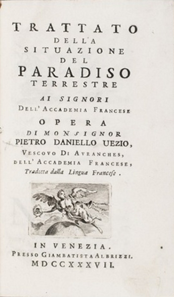
Clique nas imagens para aumentar. HUET. (Pierre Daniel) TRATTATO DELLA SITUAZIONE DEL PARADISO TERRESTREai signori Dell’Accademia Francese OPERE DI MONSIGNOR PIETRO DANIELLO UEZIO, Vescovo Di Avranches, dell’Accademia Francese, Tradotta dalla Lingua Francese. IN VENEZIA. Presso Giambatista Albrizzi. MDCCXXXVII. [1737]. In 8 (de 15x9,5 cm) com [xliv], 234 págs. Encadernação da época inteira de pele com ferros a ouro na lombada. Ilustrado com um frontispício gravado a chapa por Orsolini incorporando um mapa, as armas gravadas do dedicatário Marc"Antonio Morosini por cima da dedicatória e um mapa gravado desdobrável (de 22x19 cm) da Arábia, Golfo Pérsico, Médio Oriente e Cáucaso. Com um pequeno abrasão no canto inferior esquerdo do frontispício, mas de resto em muito bom estado. Encadernação com alguns pequenos picos de traça e com as folhas de guarda acastanhadas, mas de resto também muito bom. Uma tentativa fascinante de aplicar a ciência emergente da geografia a uma questão religiosa. Primeira e única edição italiana de um livro que tenta determinar a localização do Paraíso bíblico (o Jardim do Éden) através de uma extensa análise de fontes bíblicas e outras, pelo estudioso jesuíta e membro da Académie Française, Pierre Daniel Huet (1630-1721), bispo de Avranches. Huet relata as várias teorias anteriores sobre a localização do Paraíso, que o colocavam em todo o lado, desde debaixo da terra até à lua. O mapa de Huet, aqui copiado da edição francesa, mostra o Médio Oriente desde o Mar Vermelho e o Golfo, a sul, até ao Mediterrâneo oriental (incluindo Chipre), Arménia e Mar Cáspio, a norte. Uma linha pontilhada indica as fronteiras do 'Éden' ou 'Paradis Terrestre' na Babilónia, entre a confluência dos rios Tirgris e Eufrates (mas mostra a confluência onde eles se aproximam um do outro, perto da atual Bagdade) e o Golfo. Isto coloca-a perto da atual Al Basrah, no Iraque. As cidades de 'Aracca' e 'Talatha' são mostradas dentro dos limites do Paraíso. Entre as localizações do Paraíso sugeridas pelos estudiosos e filósofos a localização de Pierre Daniel Huet é a mais famosa dos tempos modernos. As primeiras tentativas de localização geográfica do paraíso remontam ao século VI. Com a expansão do conhecimento geográfico, o lugar atribuído ao Paraíso veio contrastar com a experiência do mundo real, ou seja, foi demonstrado que havia mais espaço para o Paraíso do que se estimava na era medieval, e o jardim do Éden foi movido de uma extremidade do mundo conhecido para a outra, da Mesopotâmia para a África Oriental, do Sudeste da África para a costa leste da Índia, e a questão da localização do Paraíso foi reconhecida como um problema racionalmente insolúvel no decurso do Renascimento. No século XVI recomeçou a tentativa de uma determinação geográfica, conforme publicado em várias edições protestantes sobre o Paraíso.
Contemporary full leather binding, with gilt tools on spine. Illustrated with a metal plate etched frontispiece by Orsolini incorporating a map, the engraved arms of the dedicatee Marc"Antonio Morosini above the dedication and a fold-out engraved map (22x19 cm) of Arabia, the Persian Gulf, the Middle East and the Caucasus. With a small abrasion in the lower left corner of the frontispiece, but otherwise in very good condition. Binding with a couple small worm holes and with the endpapers browned, but otherwise also very good. A fascinating attempt to apply the emerging science of geography to a religious question. First and only Italian edition of a book attempting to determine the location of the Biblical Paradise (the Garden of Eden) through an extensive analysis of Biblical and other sources, by the Jesuit scholar and member of the Académie Française, Pierre Daniel Huet (1630-1721), Bishop of Avranches. Huet recounts the various earlier theories about the location of Paradise, which placed it everywhere from under the ground to on the moon. Huet"s map, here copied from the French edition, shows the Middle East from the Red Sea and the Gulf in the south to the eastern Mediterranean (including Cyprus), Armenia and the Caspian Sea in the north. A dotted line indicates the borders of 'Eden' or 'Paradis Terrestre' in Babylonia, between the confluence of the Tirgris and Euphrates rivers (but it shows the confluence where they approach each other near today"s Bagdad) and the Gulf. This places it near present-day Al Basrah in Iraq. The towns of 'Aracca' and 'Talatha' are shown inside the boundaries of Paradise. Amongst the famous locations of Paradise, by scholars and philosophers, the one referred to by Pierre Daniel Huet is the most famous of modern times. The first attempts to geographically locate paradise date back to the 6th Century. The expansion of geographical knowledge assigned to Paradise came in contrast to the experience of the real world, as it had been shown that Paradise was larger than what was believed in the Middle Ages, and the Garden of Eden was moved from one end of the known world to another, from Mesopotamia to East Africa, and then from Southeast Africa to the east coast of India. The question of the location of Paradise was recognized as a rationally unsolvable problem in the course of the Renaissance period. In the 16th Century began an attempt for a geographical determination; as published in various Protestant editions on the Paradise. Referências/References>/p> Mokre, Kartographie des Imaginären, in: Petschar, Alpha & Omega (2000), pp. 27-31; Referência: 1405JC061
Local: M-17-E-20 Indisponível Caixa de sugestões A sua opinião é importante para nós. Se encontrou um preço incorrecto, um erro ou um problema técnico nesta página, por favor avise-nos. 
Outras Sugestões
|
Pesquisa Simples


|
|||||||
 |
||||||||
|
 English
 In octavo. 15x9.5 cm. [xliv], 234 pp.