
Home |
Temáticas |
Catálogos |
Pedidos |
| |
|||||||
|

|
RUGENDAS. (Johann Moritz) HABITANTE DE GOYAS, QUADRO A ÓLEO PINTADO SOBRE MADEIRA. |
|
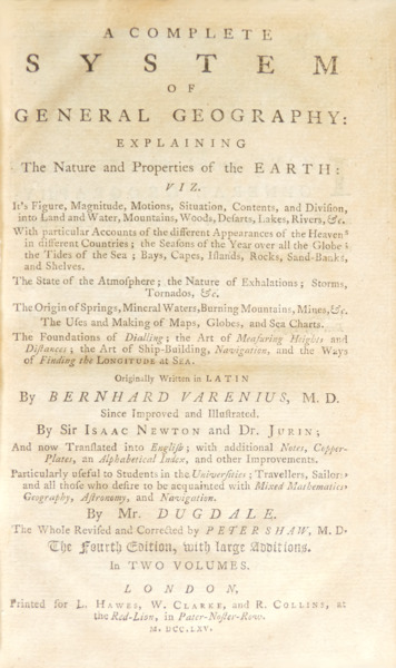
Clique nas imagens para aumentar. VARENIUS. (Bernhardus) A COMPLETE SYSTEM OF GENERAL GEOGRAPHY:EXPLAINING The Nature and Properties of the EARTH: VIZ. [...] Originally Written in LATIN by BERNHARD VARENIUS, M. D. Since Improved and Illustrated. By Sir Isaac Newton and Dr. Jurin; And now Translated into English; with additional Notes, Copper-Plates, an Alphabetical Index, and other Improvements. Particularly useful to Students in the Universities; Travellers, Sailors, and all those who desire to be acquainted with Mixed Mathematics, Geography, Astronomy, and Navigation. By Mr. DUGDALE. The Whole Revised and Corrected by Peter Shaw, M. D. The Fourth Edition, with large Additions. In TWO VOLUMES. LONDON, Printed for L. Hawes, W. Clarke, and R. Collins, at the Red-Lion, in Pater-Noster-Row. M. DCC. LXV. [1765]. 2 Volumes in 8.º de 20x13 cm. Com xxiv, 528, [xii]; xvi, 529-898, [xxvi] págs. Paginação contínua do primeiro ao segundo volume. Encadernações da época inteiras de pele, com nervos, rótulos vermelhos e castanhos, e ferros a ouro nas lombadas. Incluem fitas marcadoras em tecido. Cortes das folhas mosqueados a verde. Ilustrado com tabelas no texto, destacando-se a Table of meridional parts, or miles to every other minute of the meridian entre as páginas 875 e 890; e com 6 gravuras desdobráveis no final de cada volume, numeradas de I a XII, reunindo um total de 49 detalhadas figuras que são referidas ao longo da obra, desde mapas mundiais de grande escala a desenhos técnicos e diagramas. Frontispício desenhado por John Devoto e gravado por Gerard Vandergucht. Ornamentado com belas xilogravuras: Cabeções e iniciais decoradas com motivos vegetalistas, combinando flores, frutas, folhas, vasos, etc., incluindo por vezes alguns animais, como águias. A separar os capítulos encontram-se vinhetas um pouco menores, mas igualmente detalhadas e cuidadas, e ocasionais florões de remate de variáveis dimensões, de que são exemplos os das páginas 102, 134, 164, 229 e 279. Impresso em papel de qualidade, muito limpo. Notas de rodapé dispostas em duas colunas. Exemplar muito estimado, apresentando apenas pequenos picos de traça à cabeça das páginas 833 a 850. Primeiras páginas do primeiro volume em numeração romana com prefácio do tradutor e índice de conteúdos, tanto neste como no segundo. Nota de recomendação de James Hodgson (Master of the Royal Mathematical School, and Fellow of the Royal Society, 1732) no verso das folhas de rosto. As últimas páginas do segundo volume incluem, além das 6 gravuras desdobráveis, um extenso índice remissivo. Contém a seguinte descrição do conteúdo da obra nas folhas de rosto: «[Explaining] It"s Figure, Magnitude, Motionsm Situation, Contents, and Division, into Land and Water, Mountains, Woods, Desarts [sic], Lakes, Rivers, &c. With particular Accounts of the different Countries; the Seasons of the Year over all the Globe; the Tides of the Sea; Bays, Capes, Islands, Rocks, Sand-Banks, and Shelves. The State of the Atmosphere; the Nature of Exhalations; Storms, Tornados, &c. The Origin of Springs, Mineral Waters, Burning Mountains, Mines, &c. The Uses and Making of Maps, Globes and Sea Charts. The Foundation of Dialling; the Art of Measuring Heights and Distances; the Art of Ship-Building; Navigation; and the Ways of Finding the Longitude at Sea.» A obra organiza-se em três partes: «The Absolute, or Independent Part», que ocupa todo o primeiro volume; «The Relative Part» que ocupa metade do segundo volume, das páginas 529 a 667; e «The Comparative Part» que finaliza o segundo volume, a partir da página 668. Obra rara. Muito importante para a história e o desenvolvimento da Geografia moderna, na qual o autor se esforçou por estabelecer os princípios gerais da disciplina numa ampla base científica, de acordo com os conhecimentos da sua época. Tratou o tema da geografia com um espírito verdadeiramente filosófico e a sua obra manteve-se durante muito tempo como o melhor tratado existente sobre geografia científica e comparada. Publicada pela primeira vez em 1650, esta foi uma das primeiras obras de geografia a serem impressas. Contribuiu para a elevação do estatuto e da independência da disciplina, que nesta época era maioritariamente ensinada no âmbito de outras, como a matemática, a astronomia e a filosofia natural. Quarta edição da tradução para inglês. A magnum opus de Bernhardt Varenius foi publicada em 1650, por L. Elzevir, em Amsterdão. Redigida em latim, saiu sob o título: Geographia Generalis, sendo revista e reeditada várias vezes ao longo dos séculos XVII e XVIII. A repercussão da obra foi claramente amplificada pelo apreço que Sir Isaac Newton nutriu por ela: o eminente físico inglês organizou duas edições publicadas pela Cambridge, em 1672 e 1681, complementando e introduzindo importantes contributos baseados nos seus estudos. Em 1712, James Jurin, Roger Cotes e Edmund Halley, todos nomes ligados a Newton, organizaram uma nova versão, atualizada pelos feitos da física newtoniana. Data de 1715 a primeira edição italiana, publicada em Nápoles; e de 1718 a primeira edição russa que, baseada na primeira edição de Newton, serviu de manual para oficiais da marinha. Em 1733 surgiu a primeira edição em inglês, traduzida por Dugdale, e saíram a segunda e a terceira edição logo em 1734 e 1736; esta última revista por Shaw. Após 1750, foram editadas traduções para o holandês, para o francês e para o turco. A obra de Varenius é reconhecida como um marco na história da geografia. Ao incorporar uma metodologia baseada na matemática, experimentação e mensuração, Varenius criou uma geografia científica fundamentada nos princípios baconianos, tornando-a uma ciência indutiva, empírica e experimental. Siegmund Günther, um importante historiador da geografia clássica, afirma que Varenius estabeleceu o primeiro sistema para o ensino de geografia verdadeiramente digno desse nome, garantindo-lhe um lugar destacado na ciência - um claro precursor da geografia moderna. Varenius foi pioneiro ao incorporar o heliocentrismo desenvolvido por Copérnico, Kepler e Galileu Galilei na sua obra; ao aplicar preceitos cartesianos à geografia, como a predileção pela matemática como sistema organizacional apriorístico do conhecimento; ao separar completamente a geografia de premissas religiosas; e ao apresentar um diálogo crítico com as mais novas informações oriundas dos descobrimentos marítimos. Ao apresentar a obra, Varenius faz uma divisão metodológica quanto ao conhecimento geográfico. A Geografia, para Varenius, deveria iniciar a sua análise debruçando-se sobre aspectos gerais relativos à forma, dimensões e posição da Terra no Universo: a Geografia Geral, sobre a qual se debruça. Divide-a em três partes: Parte Absoluta; Parte Relativa; e Parte Comparativa. A primeira considera factos matemáticos relacionados com a Terra como um todo: a sua figura, dimensões, movimentos, a sua medição, etc. A segunda parte investiga a forma como a Terra é afetada pelo Sol e pelas estrelas: os climas, as estações, a diferença de tempo aparente em diferentes lugares, as variações na duração do dia, etc. A terceira parte trata brevemente das divisões da superfície da Terra, das suas posições relativas, da construção de globos e mapas, da longitude, da navegação, etc. Varenius afirma que, apenas após estarem enunciadas claramente as proposições gerais, deveria a Geografia discorrer sobre os fatores humanos, e caracteristicas dos locais, a que ele chama de Geografia Especial. Nesta se inserem: estatura dos habitantes, vida, alimento e bebida, origem, etc; Trabalhos e técnicas, mercadorias e preços; Virtudes e vícios, inteligência, conhecimentos; Costumes infantis, o matrimônio, a morte; Forma de expressão e língua; Regime Político; Religião e situação da Igreja; Cidades; Feitos famosos; Homens ou mulheres ilustres, artistas, inventos. A morte prematura do autor impediu a sua possível trajetória intelectual rumo à publicação de uma Geografia Especial, que complementaria a presente obra. Ao situar a geografia humana naquilo que ele chama de Geografia Especial, Varenius assume a separação entre o homem e a natureza, entre o homem e Deus, na sua Geografia Geral. Constitui um marco na Ciência Moderna, que abriu caminho para a revolução newtoniana. Bernhardt Varenius (c. 1621, Hitzcker - c. 1650, Leiden) foi um importante geógrafo. Apesar de ter tido uma vida muito curta, Varenius viveu intensamente a tensão entre os escolásticos e os cartesianos, assim como entre os luteranos e os calvinistas. No plano externo, ou seja, no social, Varenius viveu o esplendor da Liga Hanseática e os desdobramentos da Guerra dos Trinta Anos (1616-1648), que terminou com a chamada paz de Westfália. Natural de Hitzacker, cidade onde residia o duque de Braunschweig-Lüneburg, Bernhard veio de uma família de fé luterana, com o seu pai, Heinrich, a atuar como pastor da corte do duque. Após a morte prematura da mãe, a família mudou-se para Uelzen, onde Varenius e o seu irmão August passaram a adolescência. Vindo de uma linhagem de teólogos e professores, os irmãos usufruiram, durante este período, de uma educação sólida a título particular. Bernhard terá estudado entre 1640 e 1643 no Akademisches Gymnasium, em Hamburgo. Esta era uma instituição que ocupava um papel intermediário entre a escola secundária e a universidade. Oferecia lições de disciplinas universitárias, não somente da filosofia, mas também de direito, entre outras. Na época, o reitor do Gymnasium era Joachim Jungius (1587-1657), um sábio notável da época que se tornou amigo e conselheiro de Varenius, e cuja influência foi crucial para o seu desenvolvimento académico. Passou também pela Universidade de Königsberg entre 1643 e 1645, mas, após experienciar a má qualidade do ensino desta instituição, acabou por se mudar para a renomada Universidade de Leiden, na Holanda, onde continuou os seus estudos em filosofia, matemática e medicina. As circunstâncias políticas e financeiras, incluindo os impactos da Guerra dos Trinta Anos, moldaram a trajetória de Varenius. A destruição da cidade de Ülzen, onde residia a família, e a consequente perda de herança deixaram-no numa situação financeira precária. Varenius terminou os seus estudos sem ter obtido o título de médico, provavelmente em 1647, e mudou-se para Amsterdão a fim de ganhar a vida por meio do ensino particular e, assim, financiar a continuação dos seus estudos. Contudo, as suas tentativas de encontrar emprego foram frustradas devido à sua fé luterana, numa cidade declaradamente calvinista. Bernhard volta então para Leiden para concluir os seus estudos em medicina, obtendo, em 1649, o grau de doutor em medicina com a tese Disputatio Medica Inauguralis, De Febri in Genere. Não se sabe onde Varenius terá estudado geografia, nem quais as fontes e materiais que teve disponíveis, mas é certo que terá optado por elaborar a sua Geographia Generalis devido à situação económica e política dos Países Baixos que, desde o fim do século XVI, se haviam estabelecido como uma potência no comércio internacional, com elevado poder colonial; promovendo e sustentando navegadores, cartógrafos e geógrafos, que eram contemplados com bolsas e elevados salários pela Companhia Holandesa das Índias Orientais, dado que estas profissões atendiam às necessidades do processo de acumulação capitalista, promovendo o intercâmbio comercial e cultural entre diversas regiões do mundo. Na dedicatória da Geographia Generalis aos cônsules de Amsterdão, Varenius revela a sua busca por apoio financeiro e reconhecimento intelectual: «Primeiro, porque em toda a orbe da Terra não há cidade que mais necessite do conhecimento da Geografia que esta vossa, nem nenhuma que mais a utilize por suas admiráveis navegações a todos os rincões da Terra. Segundo, porque com as navegações de vossa gente, cresceu não pouco o estudo da Geografia [...]. Terceiro porque sei que sois protetores e promotores de toda a classe de investigações e, portanto, não duvido que considerareis também em alto grau o estudo geográfico. Motivo de louvor para vós é o fato de que benignamente favoreçais, alimentais e se esforçais em promover aos estudiosos [...], concedais também a mim [...] que possa louvar vossa generosidade.» (VARENIUS, 1672, p. 13). Embora a sua vida tenha sido abruptamente interrompida em 1650, aos 28 anos, Bernhard Varenius deixou um legado duradouro. O seu trabalho inovador e a sua abordagem interdisciplinar influenciou profundamente o desenvolvimento da geografia.
Illustrated with tables in the text, notably the Table of meridional parts, or miles to every other minute of the meridian between pages 875 and 890; and with 6 fold-out engravings at the end of each volume, numbered I to XII, bringing together a total of 49 detailed figures that are referred to throughout the work, from large-scale world maps to technical drawings and diagrams. Frontispiece designed by John Devoto and engraved by Gerard Vandergucht. Ornamented with beautiful woodcut engravings. Headpieces and initials decorated with plant motifs, combining flowers, fruit, leaves, vases, etc., sometimes including animals such as eagles. Separating the chapters are slightly smaller vignettes, but just as detailed and careful, and occasional finishing fleurons of varying sizes, examples of which are on pages 102, 134, 164, 229 and 279. Printed on quality paper, very clean. Footnotes arranged in two columns. Very well-preserved copy, with only small moth holes at the head of pages 833 to 850. First pages of first volume in Roman numerals with translator"s preface and table of contents, both in this volume and in the second. Note of recommendation from James Hodgson (Master of the Royal Mathematical School, and Fellow of the Royal Society, 1732) on the back of the title pages. The last pages of the second volume include, in addition to the 6 fold-out engravings, an extensive index. Contains the following description of the contents of the work on the title pages: «[Explaining] It"s Figure, Magnitude, Motionsm Situation, Contents, and Division, into Land and Water, Mountains, Woods, Desarts [sic], Lakes, Rivers, &c. With particular Accounts of the different Countries; the Seasons of the Year over all the Globe; the Tides of the Sea; Bays, Capes, Islands, Rocks, Sand-Banks, and Shelves. The State of the Atmosphere; the Nature of Exhalations; Storms, Tornados, &c. The Origin of Springs, Mineral Waters, Burning Mountains, Mines, &c. The Uses and Making of Maps, Globes and Sea Charts. The Foundation of Dialling; the Art of Measuring Heights and Distances; the Art of Ship-Building; Navigation; and the Ways of Finding the Longitude at Sea.» The work is organised into three parts: 'The Absolute, or Independent Part', which takes up the whole of the first volume; 'The Relative Part', which takes up half of the second volume, from pages 529 to 667; and 'The Comparative Part', which ends the second volume, starting on page 668. Rare work. Very important for the history and development of modern geography, in which the author endeavoured to establish the general principles of the discipline on a broad scientific basis, in accordance with the knowledge of his time. He treated the subject of geography in a truly philosophical spirit and his work has long remained the best existing treatise on scientific and comparative geography. First published in 1650, this was one of the first works on geography to be printed. It contributed to raising the status and independence of the subject, which at this time was mostly taught in the context of others, such as maths, astronomy and natural philosophy. Fourth edition of the English translation. The magnum opus by Bernhardt Varenius was published in 1650 by L. Elzevir in Amsterdam. Written in Latin, it was released under the title Geographia Generalis, beeing revised and reissued several times during the 17th and 18th centuries. The work"s repercussions were clearly amplified by Sir Isaac Newton"s appreciation of it: the eminent English physicist organised two editions published by Cambridge in 1672 and 1681, complementing and introducing important contributions based on his studies. In 1712, James Jurin, Roger Cotes and Edmund Halley, all names linked to Newton, organised a new version, updated by the achievements of Newtonian physics. The first Italian edition, published in Naples, dates back to 1715; and the first Russian edition, based on Newton"s first edition, served as a manual for naval officers in 1718. In 1733 the first English edition appeared, translated by Dugdale, and the second and third editions came out in 1734 and 1736, the latter revised by Shaw. After 1750, translations into Dutch, French and Turkish were published. Varenius" work is recognised as a milestone in the history of geography. By incorporating a methodology based on maths, experimentation and measurement, Varenius created a scientific geography founded on Baconian principles, making it an inductive, empirical and experimental science. Siegmund Günther, an important historian of classical geography, claims that Varenius established the first system for teaching geography truly worthy of the name, guaranteeing it a prominent place in science - a clear precursor to modern geography. Varenius was a pioneer in incorporating the heliocentrism developed by Copernicus, Kepler and Galileo Galilei into his work; in applying Cartesian precepts to geography, such as the predilection for mathematics as an aprioristic organisational system of knowledge; in completely separating geography from religious premises; and in presenting a critical dialogue with the newest information coming from maritime discoveries. When introducing the work, Varenius makes a methodological division in terms of geographical knowledge. Geography, for Varenius, should begin its analysis by looking at general aspects relating to the shape, dimensions and position of the Earth in the Universe: the General Geography, on which he focuses. It is divided into three parts: Absolute Part; Relative Part; and Comparative Part. The first considers mathematical facts related to the Earth as a whole: its figure, dimensions, movements, its measurement, etc. The second part investigates how the Earth is affected by the Sun and stars: climates, seasons, the difference in apparent time in different places, variations in the length of the day, etc. The third part briefly deals with the divisions of the Earth"s surface, their relative positions, the construction of globes and maps, longitude, navigation, etc. Varenius states that only after the general propositions have been clearly stated should Geography discuss human factors and local characteristics, which he calls Special Geography. This includes: stature of the inhabitants, life, food and drink, origin, etc.; Works and techniques, goods and prices; Virtues and vices, intelligence, knowledge; Children"s customs, marriage, death; Form of expression and language; Political regime; Religion and the situation of the Church; Cities; Famous deeds; Illustrious men or women, artists, inventions. The author"s premature death prevented his possible intellectual trajectory towards the publication of a Special Geography which would complement the present work. By situating human geography in what he calls the Special Geography, Varenius assumes the separation between man and nature, between man and God, in his General Geography. It is a milestone in modern science, which paved the way for the Newtonian revolution. Bernhardt Varenius (c. 1621, Hitzcker - c. 1650, Leiden) was an important geographer. Although he lived a very short life, Varenius lived intensely through the tension between the Scholastics and the Cartesians, as well as between the Lutherans and the Calvinists. On an external level, i.e. on a social level, Varenius lived through the splendour of the Hanseatic League and the aftermath of the Thirty Years" War (1616-1648), which ended with the so-called Peace of Westphalia. Born in Hitzacker, the town where the Duke of Braunschweig-Lüneburg resided, Bernhard came from a family of Lutheran faith, with his father, Heinrich, acting as the Duke"s court pastor. After his mother"s premature death, the family moved to Uelzen, where Varenius and his brother August spent their adolescence. Coming from a line of theologians and teachers, the brothers enjoyed a solid private education during this period. Bernhard is said to have studied between 1640 and 1643 at the Akademisches Gymnasium in Hamburg. This was an institution that occupied an intermediary role between secondary school and university. It offered lessons in university subjects, not only philosophy, but also law, among others. At the time, the rector of the Gymnasium was Joachim Jungius (1587-1657), a notable scholar of the time who became Varenius" friend and counsellor, and whose influence was crucial to his academic development. He also attended the University of Königsberg between 1643 and 1645, but after experiencing the poor quality of teaching at this institution, he ended up moving to the renowned University of Leiden, in the Netherlands, where he continued his studies in philosophy, maths and medicine. Political and financial circumstances, including the impact of the Thirty Years" War, shaped Varenius" career. The destruction of the town of Ülzen, where his family lived, and the consequent loss of inheritance left him in a precarious financial situation. Varenius finished his studies without obtaining a medical degree, probably in 1647, and moved to Amsterdam in order to earn a living through private tutoring and thus finance the continuation of his studies. However, his attempts to find work were frustrated by his Lutheran faith in a city that was avowedly Calvinist. Bernhard then returned to Leiden to complete his studies in medicine, obtaining a doctorate in medicine in 1649 with the thesis Disputatio Medica Inauguralis, De Febri in Genere. It is not known where Varenius studied geography, nor what sources and materials he had available, but it is certain that he chose to elaborate his Geographia Generalis due to the economic and political situation of the Netherlands which, since the end of the 16th century, had established itself as a power in international trade, with high colonial power; promoting and supporting navigators, cartographers and geographers, who were awarded grants and high salaries by the Dutch East India Company, since these professions met the needs of the process of capitalist accumulation, promoting commercial and cultural exchange between different regions of the world. In the dedication of Geographia Generalis to the Amsterdam consuls, Varenius reveals his quest for financial support and intellectual recognition: «Firstly, because in the whole orb of the Earth there is no city that needs the knowledge of Geography more than yours, nor any that uses it more for its admirable navigations to all corners of the Earth. Secondly, because with your people"s navigations, the study of Geography has grown not a little [...]. Thirdly, because I know that you are the protectors and promoters of all kinds of research and, therefore, I have no doubt that you will also hold the study of geography in high regard. I praise you for the fact that you so kindly favour, nourish and endeavour to promote scholars [...], may you also grant me [...] that I may praise your generosity.» (VARENIUS, 1672, p. 13). Although his life was abruptly cut short in 1650 at the age of 28, Bernhard Varenius left a lasting legacy. His innovative work and interdisciplinary approach profoundly influenced the development of geography. Referências/References: Referência: 2404SB014
Local: M-9-F-67 Caixa de sugestões A sua opinião é importante para nós. Se encontrou um preço incorrecto, um erro ou um problema técnico nesta página, por favor avise-nos. 
Outras Sugestões
|
Pesquisa Simples


|
|||||||
 |
||||||||
|
 English
 2 Volumes in octavo. 20x13 cm. xxiv, 528, [xii]; xvi, 529-898, [xxvi] pp. Continuous pagination from the first to the second volume. Contemporary full leather bindings, with raised bands, red and brown labels, and gilt tools on the spines. Includes cloth marker ribbons. Mottled green edges.