
Home |
Temáticas |
Catálogos |
Pedidos |
| |
|||||||
|

|
RUGENDAS. (Johann Moritz) HABITANTE DE GOYAS, QUADRO A ÓLEO PINTADO SOBRE MADEIRA. |
|
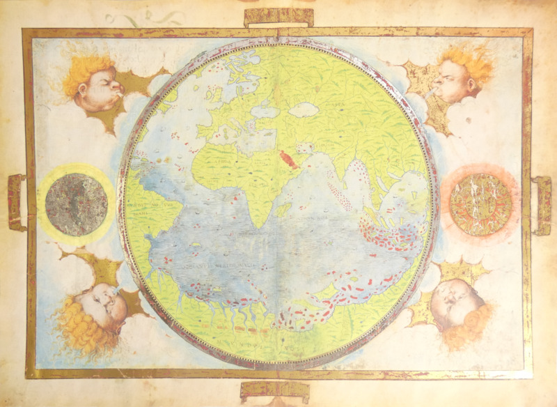
Clique nas imagens para aumentar. HOMEM. (Lopo), Pedro Reinel e Jorge Reinel. ATLAS MILLER - BIBLIOTHÈQUE NATIONALE DE FRANCE, PARIS. [FAC-SÍMILE + LIVRO DE ESTUDO]Circa 1519. [M. Moleiro. Barcelona. 2003] 5 Folhas de pergaminho de 41,5x59 cm. e 1 folha de pergaminho de 61x117 cm., acondicionadas em dois belos estojos do editor. As 5 folhas num estojo rectangular com duas abas que abrem para cima e a folha do planisfério enrolada num estojo de secção triangular. Os dois são forrados em seda vermelha com estampagens a ouro. Ilustrado com 10 mapas. Exemplar n.º 266 de uma tiragem de 987. Inclui uma pasta com um certificado notarial que assegura a autenticidade e unicidade deste exemplar. Fac-símile luxuoso e muito cuidado, elaborado com extrema fidelidade artística e material e acompanhado do seguinte livro, publicado 3 anos depois devido a atrasos na redacção de alguns artigos, com importantes ensaios sobre o conteúdo do Atlas, seus autores e o contexto da sua produção: PINHEIRO MARQUES. (Alfredo), Luís Filipe Thomaz e Bernardo Sá Nogueira. ATLAS MILLER [ESTUDOS] Diseño gráfico: Gemma Recasens. Directora editorial: Mónica Miró. Equipo editorial: Maria Algàs, María José Cantón. Traducción del portugués al español: Basilio Losada. M. Moleiro Editor. Barcelona. 2006. De 35,5x25cm. Com 427, [ii] págs. Encadernação do editor inteira de tela azul, com sobrecapa de proteção e fita marcadora em tecido. Profusamente ilustrado, incluindo desdobráveis. O Atlas Miller, realizado em 1519 por Lopo Homem, Pedro Reinel e o seu filho Jorge Reinel, com iluminuras de António de Holanda, é uma das maravilhas da cartografia portuguesa do século XVI e considerado consensualmente como um dos mais belos mapas do mundo. É um trabalho cartográfico luxuosamente iluminado, que retrata o mundo já conhecido em conjunto com iluminuras e decorações sumptuosas, integrando dados recentemente obtidos dos descobrimentos portugueses, mas ainda com uma visão baseada nos conceitos geográficos de Ptolomeu, autêntica obra prima do século XVI, geograficamente conservadora e artisticamente sumptuosa. A concepção geográfica espelha a glória do imperialismo manuelino, que foi o primeiro império global da história, apresentando simultaneamente a metade do globo terrestre que tinha sido atribuída a Portugal pelo Tratado de Tordesilhas, em que as terras predominam sobre as águas e incluindo, pela primeira vez, a representação realista das costas de Madagáscar, das Molucas e do Brasil. Todas as cartas ilustradas com abundantes brasões e bandeiras portuguesas que pretendem demonstrar a esmagadora hegemonia do país e a sua prioridade nos descobrimentos. Glorifica o poder marítimo português, sem pôr em causa a sua estratégia de monopólio. Este magnífico conjunto de cartas geográficas artísticas foi encomendado por D. Manuel I, cerca de 1519, e segundo certos historiadores terá sido um presente matrimonial para a sua terceira mulher, Dona Leonor de Áustria, irmã do imperador Carlos V, (segundo A. Pinheiro Marques) ou terá sido uma oferta ao Papa Leão X, da família dos Medicis (segundo Luís Filipe Tomás). Nas duas hipóteses este conjunto de cartas terá sido levado para França. Na primeira, D. Leonor depois de enviuvar do rei D. Manuel casou com o rei D. Francisco I de França, levando consigo o Atlas passando este, depois, para a posse da Rainha de França, Catarina de Medicis, sobrinha neta do Papa ou na segunda hipótese o Papa não teria colocado o atlas na Biblioteca Vaticana e ele teria passado a integrar os bens da sua família e sido herdado por Catarina. Posteriormente a sua história é desconhecida (terão sido roubados durante a Revolução Francesa?) até que, em 1855, o Visconde de Santarém as comprou ao livreiro Chavanay, em Paris, as estudou e escreveu um ensaio sobre elas só publicado em 1919. No fim da sua vida o Visconde cedeu as cartas ao seu amigo Benigne-Emanuel Clément Miller a quem devia dinheiro por causa do atraso dos pagamentos que lhe eram devidos pelo governo de Portugal, ver (Cortesão, 1935). Em 1897 a viúva de Miller vendeu as cartas à Biblioteca Nacional de Paris. DESCRIÇÃO DO ATLAS: consiste em 5 fólios desenhados e pintados na frente e no verso, em conjunto com um sexto de maiores dimensões, também com um mapa em cada face. No total contabilizam-se nove mapas regionais que abrangem: Oceano Atlântico Norte, Europa do Norte, Arquipélago dos Açores, Madagáscar, Oceano Índico, Indonésia, Mar da China, Molucas, Brasil, Mar Mediterrâneo; e um planisfério. Perderam-se os mapas relativos a África, restando apenas a metade direita de um deles, com a representação de Madagáscar e de parte do Corno de África. Cada folha contêm as seguintes cartas: FOLHA 1 - Frente: Planisfério ou mapa-mundo Miller; Verso: do lado direito, página de título com o brasão de Catarina de Médici; lado esquerdo em branco. Planisfério ou mapa-mundo. Na primeira folha encontra-se o característico mapa-mundo do Atlas Miller, que se destaca por apresentar um planisfério do mundo conhecido completamente cercado por terra — uma visão ptolomaica muito invulgar e peculiar quando incluída num mapa do século XVI; e por, através de um (quiçá deliberado) enviesamento geográfico, apresentar um caminho marítimo de Portugal até à Índia e às Ilhas Molucas muito mais curto que o real. O mapa circular, com 33 cm. de diâmetro e envolto por uma faixa prateada, ocupa o centro do pergaminho. Foi desenhado e colorido no interior de uma moldura rectangular dourada, onde dos seus cantos surgem desenhadas quatro cabeças alegóricas que sopram os ventos dos «Quatro Cantos do Mundo». A moldura inclui ainda um sol dourado a Este e uma lua prateada a Oeste. Página de Título: No lado direito do verso da primeiro folha, que seria a primeira página do códice original quando dobrado, encontra-se uma legenda enquadrada por uma moldura dourada, a data de 1519 escrita a seu lado direito e uma bela gravura com as armas de Catarina de Médicis, que nasceu nesse mesmo ano. Este brasão foi adicionado após o Atlas se encontrar finalizado, e trata-se de uma marca de posse. Tendo em conta a análise heráldica do mesmo, deduz-se que terá sido gravado após Catarina enviuvar, ou seja, após 1559, embora seja possível que o Atlas já estivesse em sua posse antes desta data. Na legenda pode ler-se: «Hec est vniuersi orbis ad hanc usqe diem cogniti tabula Quam ego Lupus homo Cosmographus in clarissima Ulisipone ciuitate Anno domini nostri Millessimo quingentessimo decimo nono Jussu Emanuelis incliti lusitanie Regis collatis pluribus alijs tam vetustorum quam recentiorum tabulis magna industria et dilligenti labore depinxi.» que pode traduzir-se como «Este é um mapa do mundo inteiro conhecido até hoje, que eu, Lopo Homem, Cosmógrafo, na ilustre cidade de Lisboa, no ano de Nosso Senhor mil quinhentos e dezenove, tendo comparado muitos outros mapas antigos e modernos, desenhei com grande esforço e trabalho diligente por ordem de Manuel, renomado Rei de Portugal». FOLHA 2 - Frente: Nordeste Oceano Atlântico e Europa do Norte. Verso: na metade esquerda Oceano Atlântico Central com Açores; metade direita em branco. FOLHA 3 - Frente: Norte do Oceano Índico, com a Península Arábica e a Índia. Verso: Sul do Oceano Índico - Insulíndia à esquerda (Insulíndia 1); Madagáscar à direita. Insulíndia. O mapa da Insulíndia representa a parte oriental das ilhas do Sudeste Asiático como um caótico labirinto de ilhas, a maior parte das quais imaginadas, o que pode ser interpretado mais uma vez como uma tentativa de dissuadir outras nações de explorar as Molucas. Embora contenha vários elementos legados pela cartografia medieval, quer seja pelas ilhas imaginárias, quer pela grande massa de terra a Este que as delimita (em parte diretamente tirada do mapa do Magnus Sinus do Atlas de Ptolomeu), o mapa revela progresso na maior parte da representação cartográfica das Molucas, o que está de acordo com as recorrentes expedições portuguesas ao território, naquela época. FOLHA 4 - Frente: Golfo da Tailândia ou Magnus Sinus. Verso: na metade direita Mar da China com as Molucas (Insulíndia 2); metade esquerda em branco. FOLHA 5 - Frente: Oceano Atlântico Sudoeste, com o Brasil. Verso: folha em branco. FOLHA 6 (de maiores dimensões) - Frente: Oceano Atlântico Norte. Verso: Oceano Atlântico Nordeste, Mar Mediterrâneo, Mar Negro, Mar Cáspio, parte do Mar Vermelho e Golfo Pérsico. Cada carta apresenta linhas de latitude; extensa toponímia ao longo das linhas costeiras escrita em minúscula com tinta preta e vermelha, em dourado nas áreas geográficas; numerosas rosas-dos-ventos, com as habituais 32 linhas de orientação para as principias direções; legendas em latim com a descrição das respectivas regiões do globo. Os elementos decorativos que acompanham cada mapa são uma das características mais notável do Atlas. Tanto os oceanos como o interior dos continentes estão repletos de ilustrações que revelam uma enorme atenção ao detalhe: as miniaturas representam o modo de vida dos povos indígenas; cenas de colonização; fauna e flora típica; embarcações portuguesas e mouras, figuras mitológicas e monstros marinhos; vários governantes, cidades importantes, castelos e maravilhas arquitectónicas. Nele se encontra desenhado um grande número de costas longínquas, a maior parte delas descobertas menos de trinta anos antes, são representadas pela primeira vez de forma realista, como, por exemplo, o mapa da «Terra Brasilis», que mostra a mais minuciosa cartografia da costa brasileira à época, escassos 19 anos após a descoberta do território por Pedro Álvares Cabral; ou as de Madagáscar e das Molucas. Contudo, não obstante o detalhe e exatidão que se encontra na representação de muitas linhas costeiras, não se trata de um mapa de rotas como os que terão sido utilizados pelos navegadores portugueses e espanhóis (e dos quais nada resta, resultado de uma política de sigilo deliberadamente aplicada tanto por Espanha como por Portugal) — a sua escala não é muito pormenorizada e não menciona o domínio dos ventos e das correntes ou os perigos e dificuldades técnicas relativas às viagens. Trata-se, antes de mais, de um retrato idílico, que mostra tudo sem revelar o que era considerado segredo. Alfredo Pinheiro Marques defende a hipótese que o Atlas Miller pode ter sido concebido e usado como um objecto de contra-informação geográfica ao mais alto nível da diplomacia ibérica, ao apresentar, entre outros aspectos geográfico e náuticos errados, uma Terra fechada, sem representação do oceano Pacífico e não circum-navegável. Terá sido feito para fazer circular falsas informações junto da corte castelhana, justamente pela altura em que Fernão de Magalhães se preparava em Sevilha para a primeira circum-navegação do globo. É ainda surpreendente notar como os mesmos cartógrafos que estiveram envolvidos na elaboração do Atlas Miller estiveram também, pela mesma altura, envolvidos na preparação da viagem de Magalhães. A partir do momento em que os portugueses começaram a estabelecer uma imagem realista do caminho para a Índia, a cartografia deixou de poder ser neutra. Tornou-se indissociável da política dos Estados; pertencia-lhes e tinha de defender as suas ambições e reivindicações. O LIVRO DE ESTUDOS: Este completo e denso livro de estudos, que apresenta propostas inovadoras de interpretação dos factos, contém um pequeno texto introdutório do editor Manuel Moleiro; um prefácio por Joaquim Ferreira do Amaral; 4 textos de Alfredo Pinheiro Marques, do Centro de Estudos do Mar e das Navegações Luís de Albuquerque, 1 ensaio de Luís Filipe Thomaz, Diretor do Instituto de Estudos Orientais da Universidade Católica Portuguesa e um sexto texto da autoria conjunta dos dois historiadores referidos mais Bernardo de Sá Nogueira; As últimas páginas apresentam Notas (p. 351-401), Anexo com pequeno ensaio de Pinheiro Marques, Bibliografia e Índice. Os ensaios são os seguintes: Alfredo Pinheiro Marques – Los descubrimientos y el Atlas Miller, obra maestra de la cartografía y del arte en el Renacimiento. De uma forma geral, a interpretação das circunstâncias e motivações para a criação da obra fica a cargo de Pinheiro Marques e a leitura dos mapas de Luís Filipe F. R. Thomaz; sendo de destacar que ambos contribuem com valiosos dados históricos e propõem hipóteses, novas leituras, descrições detalhadas do Atlas e da nomenclatura geográfica. PROPRIETÁRIOS CONHECIDOS: Catarina de Medicis, Rainha de França (Florença, 1519 - Castelo de Blois, 1589) Manuel Francisco de Barros e Sousa de Mesquita de Macedo Leitão e Carvalhosa, visconde de Santarém (1791 – 1856); Emmanuel Miller (1812? – 1886); Viúva de Emmanuel Miller (18-- – 18-- ?). CARTÓGRAFOS E ARTISTAS: António de Holanda (c. 1490 – c. 1560) foi talvez o mais extraordinário e desconhecido iluminador do período renascentista activo em Portugal. Pintou num estilo gótico tardio, associado ao estilo da escola de Gent-Bruges. Além do Atlas Miller, contribui com iluminuras para a Crónica de D. João I de Fernão Lopes, o Livro de Horas de D. João III, da Rainha D.ª Leonor e de D. Manuel, os frontispícios de Leitura Nova, entre outras. Pai de Francisco de Holanda, uma outra grande figura no campo das artes em Portugal. Pedro Reinel (c. 1462 - c. 1542) foi um cartógrafo português, autor da mais antiga carta de marear portuguesa assinada (c. 1485). Jorge Reinel, (c. 1502 – c. 1575) filho de Pedro Reinel, foi também um cartógrafo de destaque. Aliás, Pedro e Jorge Reinel, foram considerados como dois dos melhores cartógrafos do seu tempo. Lopo Homem, () ativo entre 1515 e 1556, amigo (ou possivelmente familiar, segundo APM) de António de Holanda, proveniente de uma família de cartógrafos.
Copy no. 266 of a print run of 987. Includes a folder with a notarial certificate guaranteeing the authenticity and uniqueness of this copy. Luxurious and very cared for facsimile, made with extreme artistic and material fidelity and accompanied by the following book, published 3 years later due to delays in the writing of some articles, with important essays on the contents of the Atlas, its authors and the context of its production: PINHEIRO MARQUES. (Alfredo), Luís Filipe Thomaz e Bernardo Sá Nogueira. ATLAS MILLER [ESTUDOS] Diseño gráfico: Gemma Recasens. Directora editorial: Mónica Miró. Equipo editorial: Maria Algàs, María José Cantón. Traducción del portugués al español: Basilio Losada. M. Moleiro Editor. Barcelona. 2006. 35.5x25cm. 427, [ii] pp. Publisher"s full blue cloth binding, with protective dust jacket and cloth ribbon marker. Profusely illustrated, including fold-outs. The Miller Atlas, made in 1519 by Lopo Homem, Pedro Reinel and his son Jorge Reinel, with illuminations by António de Holanda, is one of the wonders of 16th century Portuguese cartography and is widely considered to be one of the most beautiful maps in the world. It is a lavishly illuminated cartographic work, which portrays the world already known together with sumptuous illuminations and decorations, integrating recently obtained data from the Portuguese discoveries, but still with a vision based on the geographical concepts of Ptolemy, an authentic 16th century masterpiece, geographically conservative and artistically sumptuous. The geographical conception reflects the glory of Manueline imperialism, which was the first global empire in history, simultaneously presenting the half of the globe that had been assigned to Portugal by the Treaty of Tordesillas, in which land predominates over water and including, for the first time, the realistic representation of the coasts of Madagascar, the Moluccas and Brazil. All the charts are illustrated with abundant Portuguese coats of arms and flags to demonstrate the country"s overwhelming hegemony and its priority in the discoveries. It glorifies Portuguese maritime power, without questioning its monopoly strategy. This magnificent set of artistic geographical charts was commissioned by King Manuel I around 1519, and according to some historians it was either a wedding present for his third wife, Dona Leonor of Austria, sister of Emperor Charles V (according to A. Pinheiro Marques) or a gift to Pope Leo X, from the Medicis family (according to Luís Filipe Tomás). In both cases, this set of charts was taken to France. In the first case, Leonor, after being widowed by King Manuel, married King François I of France and took the atlas with her, and it was later given to the Queen of France, Catherine de Medicis, the Pope"s grandniece. In the second case, the Pope didn"t put the atlas in the Vatican Library and it became part of his family"s possessions and was inherited by Catherine. Their subsequent history is unknown (were they stolen during the French Revolution?) until, in 1855, the Viscount of Santarém bought them from the bookseller Chavanay in Paris, studied them and wrote an essay about them that wasn"t published until 1919. At the end of his life, the Viscount gave the charts to his friend Benigne-Emanuel Clément Miller, to whom he owed money because of late payments owed to him by the Portuguese government, see (Cortesão, 1935). In 1897, Miller"s widow sold the charts to the National Library in Paris. DESCRIPTION OF THE ATLAS: consists of 5 folios drawn and painted on the front and back, together with a sixth larger one, also with a map on each side. In total there are nine regional maps covering: North Atlantic Ocean, Northern Europe, Azores Archipelago, Madagascar, Indian Ocean, Indonesia, China Sea, Moluccas, Brazil, Mediterranean Sea; and one planisphere. The maps relating to Africa have been lost, with only the right half of one of them remaining, showing Madagascar and part of the Horn of Africa. Each sheet contains the following charts: SHEET 1 - Front: Miller"s planisphere or world map; Back: on the right side, title page with the coat of arms of Catherine de Medici; left side blank. Planisfério ou mapa-mundo (Planisphere or world map). On the first sheet is the characteristic Miller Atlas world map, which stands out for presenting a planisphere of the known world completely surrounded by land - a very unusual and peculiar Ptolemaic view when included on a 16th century map; and for, through a (perhaps deliberate) geographical bias, presenting a maritime route from Portugal to India and the Moluccas much shorter than the real one. The circular map, 33 cm in diameter and surrounded by a silver band, occupies the centre of the parchment. It has been drawn and coloured inside a rectangular golden frame, in the corners of which four allegorical heads are drawn, blowing the winds of the 'Four Corners of the World'. The frame also includes a golden sun to the east and a silver moon to the west. Title Page: On the right-hand side of the verso of the first leaf, which would have been the first page of the original codex when folded, there is a caption framed by a gilded frame, the date 1519 written on the right-hand side and a beautiful engraving of the coat of arms of Catherine de Medici, who was born that same year. This coat of arms was added after the Atlas was finalised and is a mark of ownership. Having analysed its heraldry, we can deduce that it was engraved after Catherine was widowed, i.e. after 1559, although it is possible that the Atlas was already in her possession before this date. The caption reads: «Hec est vniuersi orbis ad hanc usqe diem cogniti tabula Quam ego Lupus homo Cosmographus in clarissima Ulisipone ciuitate Anno domini nostri Millessimo quingentessimo decimo nono Jussu Emanuelis incliti lusitanie Regis collatis pluribus alijs tam vetustorum quam recentiorum tabulis magna industria et dilligenti labore depinxi. » which can be translated as 'This is a map of the entire world known to this day, which I, Lopo Homem, Cosmographer, in the illustrious city of Lisbon, in the year of Our Lord one thousand five hundred and nineteen, having compared many other ancient and modern maps, drew with great effort and diligent labour by order of Manuel, renowned King of Portugal». SHEET 2 - Front: North-East Atlantic Ocean and Northern Europe. Back: left half Central Atlantic Ocean with Azores; right half blank. SHEET 3 - Front: North of the Indian Ocean, with the Arabian Peninsula and India. Back: South of the Indian Ocean - Insulindia on the left (Insulindia 1); Madagascar on the right. Insulíndia. The Insulindia map represents the eastern part of the Southeast Asian islands as a chaotic labyrinth of islands, most of which are imagined, which can once again be interpreted as an attempt to dissuade other nations from exploring the Moluccas. Although it contains several elements bequeathed by medieval cartography, whether it"s the imaginary islands or the large land mass to the east that delimits them (partly taken directly from the Magnus Sinus map in Ptolemy"s Atlas), the map shows progress in most of the cartographic representation of the Moluccas, which is in keeping with the recurrent Portuguese expeditions to the territory at that time. SHEET 4 - Front: Gulf of Thailand or Magnus Sinus. Back: right half China Sea with the Moluccas (Insulindia 2); left half blank. SHEET 5 - Front: Southwest Atlantic Ocean, with Brazil. Back: blank sheet. SHEET 6 (larger) - Front: North Atlantic Ocean. Back: North-East Atlantic Ocean, Mediterranean Sea, Black Sea, Caspian Sea, part of the Red Sea and the Persian Gulf. Each chart features latitude lines; extensive toponymy along the coastlines written in tiny black and red ink, in gold in the geographical areas; numerous wind roses, with the usual 32 orientation lines for the main directions; legends in Latin describing the respective regions of the globe. The decorative elements that accompany each chart are one of the Atlas"s most remarkable features. Both the oceans and the interior of the continents are filled with illustrations that reveal enormous attention to detail: the miniatures represent the way of life of indigenous peoples; scenes of colonisation; typical fauna and flora; Portuguese and Moorish vessels, mythological figures and sea monsters; various rulers, important cities, castles and architectural wonders. It shows a large number of distant coastlines, most of them discovered less than thirty years earlier, represented for the first time in a realistic way, such as the map of 'Terra Brasilis', which shows the most meticulous cartography of the Brazilian coast at the time, just 19 years after the discovery of the territory by Pedro Álvares Cabral; or those of Madagascar and the Moluccas. However, despite the detail and accuracy found in the representation of many coastlines, this is not a route map like those used by Portuguese and Spanish navigators (and of which nothing remains, result of a policy of secrecy deliberately applied by both Spain and Portugal) - its scale is not very detailed and it doesn"t mention the dominance of winds and currents or the dangers and technical difficulties involved in travelling. It is, above all, an idyllic portrait, which shows everything without revealing what was considered secret. Alfredo Pinheiro Marques defends the hypothesis that the Miller Atlas may have been conceived and used as an object of geographical counter-information at the highest level of Iberian diplomacy, by presenting, among other erroneous geographical and nautical aspects, a closed Earth, without representation of the Pacific Ocean and not circumnavigable. It may have been done to circulate false information to the Castilian court, at the very time that Ferdinand Magellan was preparing in Seville for the first circumnavigation of the globe. It"s also surprising to note how the same cartographers who were involved in drawing up the Miller Atlas were also, around the same time, involved in preparing Magellan"s voyage. Once the Portuguese began to establish a realistic image of the road to India, cartography could no longer be neutral. It became inseparable from the politics of states; it belonged to them and had to defend their ambitions and claims. THE BOOK OF STUDIES: This complete and dense book of studies, which presents innovative proposals for interpreting the facts, contains a short introductory text by the editor Manuel Moleiro; a preface by Joaquim Ferreira do Amaral; 4 texts by Alfredo Pinheiro Marques, from the Centro de Estudos do Mar e das Navegações Luís de Albuquerque (Luís de Albuquerque Centre for Studies of the Sea and Navigations), 1 essay by Luís Filipe Thomaz, Director of Instituto de Estudos Orientais da Universidade Católica Portuguesa (Institute of Oriental Studies at the Portuguese Catholic University) and a sixth text by the two historians mentioned plus Bernardo de Sá Nogueira; The last pages have Notes (pp. 351-46), an Appendix with a short essay, a Bibliography and an Index. 351-401), an Appendix with a short essay by Pinheiro Marques, a Bibliography and an Index. The essays are as follows: Alfredo Pinheiro Marques – Los descubrimientos y el Atlas Miller, obra maestra de la cartografía y del arte en el Renacimiento In general, Pinheiro Marques is responsible for interpreting the circumstances and motivations behind the creation of the work, while Luís Filipe F. R. Thomaz is responsible for reading the maps; it should be noted that both contribute valuable historical data and propose hypotheses, new readings, detailed descriptions of the Atlas and the geographical nomenclature. KNOWN OWNERS: Catherine de Medicis, Queen of France (Florence, 1519 - Blois Castle, 1589) Manuel Francisco de Barros e Sousa de Mesquita de Macedo Leitão e Carvalhosa, Viscount of Santarém (1791 - 1856); Emmanuel Miller (1812? - 1886); Widow of Emmanuel Miller (18-- - 18-- ?). CARTOGRAPHERS AND ARTISTS: António de Holanda (c. 1490 - c. 1560) was perhaps the most extraordinary and unknown illuminator of the Renaissance period active in Portugal. He painted in a late Gothic style, associated with the style of the Gent-Bruges school. As well as the Miller Atlas, he contributed illuminations to the Crónica de D. João I by Fernão Lopes, the Livro de Horas de D. João III, the one from Queen Leonor and the one from King Manuel, the frontispieces of Leitura Nova, among others. Father of Francisco de Holanda, another great figure in the arts in Portugal. Pedro Reinel (c. 1462 - c. 1542) was a Portuguese cartographer, author of the oldest signed Portuguese seafaring chart (c. 1485). Jorge Reinel, (c. 1502 - c. 1575) son of Pedro Reinel, was also an outstanding cartographer. In fact, Pedro and Jorge Reinel were considered to be two of the best cartographers of their time. Lopo Homem, () active between 1515 and 1556, friend (or possibly relative, according to Pinheiro Marques) of António de Holanda, from a family of cartographers. Referências/References: M. Moleiro Editor. Referência: 2310SB006
Local: M-17-TOP-4 Caixa de sugestões A sua opinião é importante para nós. Se encontrou um preço incorrecto, um erro ou um problema técnico nesta página, por favor avise-nos. 
Outras Sugestões
|
Pesquisa Simples


|
|||||||
 |
||||||||
|
 English
 5 parchment sheets measuring 41.5x59 cm and 1 parchment sheet measuring 61x117 cm, packed in two beautiful publisher"s cases. The 5 sheets in a rectangular case with two flaps that open upwards and the planisphere sheet rolled up in a triangular case. Both are lined in red silk with gold embossing. Illustrated with 10 maps.