Home |
Temáticas |
Catálogos |
Pedidos |
| |
|||||||
|

|
RUGENDAS. (Johann Moritz) HABITANTE DE GOYAS, QUADRO A ÓLEO PINTADO SOBRE MADEIRA. |
|
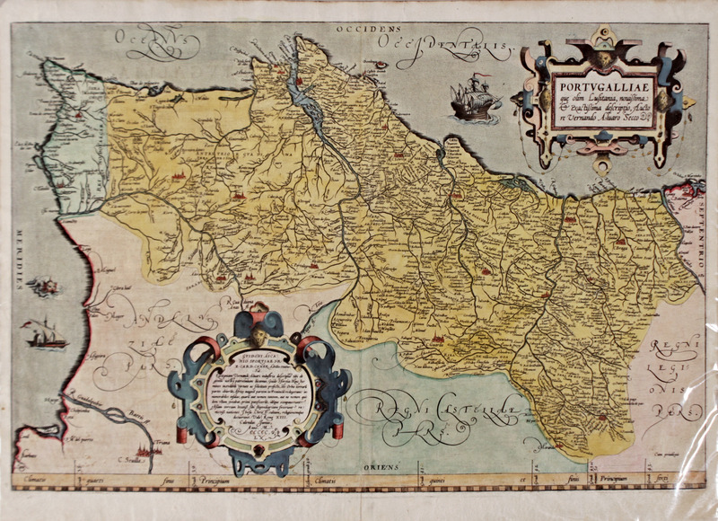
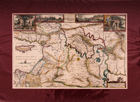
Clique nas imagens para aumentar. ÁLVARO SECO. CARTOGRAFIA. SÉC. XVI [O MAIS ANTIGO MAPA DE PORTUGAL].PORTUGALLIAE que olim Lusitânia, novissima & exactissima descriptio, Auctore Vernando Álvaro Secco. [Subtítulo com prolação]: GVIDONE ASCANIO SFORTIAE S. R. E. CARD. CAMER. Achilles Statius. Sal. Lusitaniem Vernandi Alvari industria descripta tibi ob gentis nostre patrocinium dicamos, Guido Sfortia: Hinc Homines incredibili virtute ac felicitate profecti,ões Orbis terrariu[m] partes obieru[n]t, Africa magna[m] partem Provincia[m] redegerunt: innumerabiles insulas, quarum aut nomen tantum, aut ne nomem quidem vllum extabat, primi patefeceru[n]t, inde[m]que occupaverunt: Asiam terram beatiss. sibi stipendiaram fecerunt: remotiss. nationes Jhesu Christi cultum, religionemque docuerunt. Vale, Rome XIII. Calendas Junias. Anno. M. CCCCC. LX [1560]. 1 fólio duplo da edição quinhentista latina do atlas Theatrum Orbis Terrarum de Abram Ortel, conhecido por Ortelius. De 38,5x53 cm. Edição latina e impressa a partir de chapa de cobre, colorida manualmente. Título resumido em português: “Portugal que antigamente era Lusitânia, descrição novíssima e exactíssima pelo autor Álvaro Seco. Em Roma aos 13 de Junho de 1560”. [Mapa apresentando as fronteiras políticas e a demarcação dos territórios eclesiásticos/administrativos]. Com escala de latitudes. No verso contém o texto latino impresso com a descrição Portugal [texto em Latim desde Portugallia até extenditur]. Para a identificação e contexto deste mapa contribuem, entre outras, as duas seguintes obras: BINDING (Paul) IMAGINED CORNERS. Exploring the World’s First Atlas. Headline Book Publishing. London. 2003; e ALVES FERREIRA E OUTROS. O MAIS ANTIGO MAPA DE PORTUGAL (1561). Coimbra. Instituto de Alta Cultura. 1957. A posição em que se encontra o mapa pode inicialmente constituir motivo de estranheza, porém, tanto os autores nacionais como os estrangeiros são unânimes ao afirmarem que essa era a visão de Portugal nesta época, um país onde as suas principais riquezas, poder e território se prolongavam pelo mar oceano. Binding, 2003:172, refere que “Quase todos os mapas utilizados no Theatrum são orientados para norte na linha do principal mentor de Ortelius, Ptolomeu, mas o de Portugal tem orientação ocidental. Isto pode ser justificado uma vez que, de facto, serve brilhantemente para enfatizar o oceano Atlântico, que se estende para oeste, como a chave para o carácter e destino daquele país”. Alves Ferreira e outros (1957:14) pensam que esta modificação da orientação habitual das cartas não foi executada por um simples motivo estético ou de arranjo gráfico. Segundo estes autores a colocação em relação a uma posição privilegiada, relativamente às ilhas atlânticas dos Açores e da Madeira, colocavam em grande evidência essa relação e suscitava o favor do seu Rei. Embora sem qualquer indicação de escala (Alves Ferreira e outros, 1951:15) julgam que a escala utilizada é a de 1:1:500.000. A parte Leste da carta (colocada em baixo) está limitada por uma escala de latitudes com o desenvolvimento de 5 graus: do 38º ao 43º. Este mapa aqui apresentado coloca Lisboa erradamente no 40º grau e lê-se sobre a escala “Lisbona Gradi 40”. Porém, quando projectada com esquadro, a latitude de Lisboa é na mesma escala deste mapa: 39º 53’. Este aspecto revela-se de suma importância para sabermos que este nosso mapa é uma das primeiras edições dos anos de 1570, que posteriormente foram corrigidas pelos códices alemães das latitudes, tal como já acontece no mapa apresentado em fac-simile por Alves Ferreira e outros (1951). Definitivamente em 1514, no Livro de Marinharia de João de Lisboa, a latitude de Lisboa encontra-se ajustada para os valores correctos e actuais: 38º 4’’. A colocação de Lisboa arredondada para o 40º grau tratava-se de uma medida expedita e política, simultaneamente para não complicar o cálculo e universalizar o conhecimento da posição da capital portuguesa como referência terrestre (vide Alves Ferreira e outros 1951:15). Cada grau desta escala está dividido em 17,5 partes, correspondendo cada uma delas a uma légua, à maneira da época. Como era habitual nas cartas, desde a antiguidade, estão indicados os paralelos que separam os diversos tipos climáticos: clima quartis, clima quintis, etc. Embora a carta não apresente qualquer grelha de meridianos os cientistas Alves Ferreira e outros (1951:16) indicam que o mapa foi feito com uma projecção cilíndrica aproximada, já que o comprimento do grau de latitude é variável de sul para norte. Quanto à técnica utilizada por Álvaro Seco os cientistas de Coimbra, completamente apoiados no seu estudo pelo Dr. Armando Cortesão, afirmam que a relação entre as distâncias dos lugares, e a perfeita proporção com os levantamentos actuais, levam à conclusão de que se utilizaram métodos matemáticos de triangulação geodésica. Nesse sentido Álvaro Seco terá trabalhado sobre uma “carta-padrão” anterior a 1530 e encomendada pelo rei D. João III. Segundo os autores de Coimbra, Portugal antecipou-se no levantamento de uma carta de conjunto, e em grande escala, cerca de 30 anos antes de qualquer outro país. Esta informação é também referida, em inglês, como corolário no estudo de Coimbra (1951:99). Este é o mais antigo mapa de Portugal existente, preparado por Fernando Álvaro Seco em 1561 e incluído no Theatrum Orbis Terrarum de Ortelius em 1570. É a primeira representação conhecida de todo o território de um estado e é um documento notável da cartografia terrestre portuguesa do século XVI. As suas coordenadas gráficas foram analisadas e comparadas com as figuras contidas num códice da Universidade de Hamburgo e datadas de antes de 1540. O problema de conhecer como o mapa pode ter sido preparado é especialmente considerado, admitindo que os cartógrafos portugueses possam ter utilizado o processo de triangulação muito antes de Snellius, quer na preparação do mapa de Seco, quer o de um mapa padrão que, de acordo com o códice mencionado, pode existir embora o seu paradeiro permaneça desconhecido. Fernando Álvaro Seco, também grafado como Vernandi Alvari Secco (século XVI) foi um cartógrafo português. Embora nada se conheça acerca da sua biografia, é o autor da primeira versão conhecida do mapa do território continental português, oferecida diplomaticamente em Roma, em Maio de 1560, com uma escala de aproximadamente 1:1.200.000. A carta foi encomendada por Aquiles Estaço para discutir as relações diplomáticas entre Portugal e a Santa Sé. As três primeiras versões dessa carta são: a edição dita “de Roma”, que apresenta na sua dedicatória a data de 1561, a de Antuérpia, de 1565, que exibe dedicatória datada de 1560 e a incluída na primeira edição do “Theatrum Orbis Terrarum”, de Abraham Ortelius, publicada em Antuérpia em 1570. Abraão Ortelius foi um compilador que às suas próprias custas mandou imprimir um conjunto de mapas de 86 autores diferentes (Binding, 2003:225) que intitulou Theatrum Orbis Terrarum. As mais perfeitas e apreciadas cartografias do seu tempo foram impressas pelo cartografo e impressor Gillis Copens van Dienst. Inicialmente foram vendidos encadernados ou soltos, tanto coloridos como por colorir (Binding, 2003:201). Ortelius orgulhava-se dos seus cartógrafos - entre os quais Álvaro Seco – que tinham contribuído para esta colectânea e os seus nomes aparecem tanto nos mapas [obtidos a partir de chapas originais, ou cópias de fólios que, apesar de arranjadas e reescritas, respeitaram a autoria e o conteúdo da edição princeps] como também aparecem os seus nomes numa lista de autores - Catalogus auctorem - num capítulo da obra de Ortelius. A atitude de Ortelius confere um mérito novo e inaugura um novo método na concepção ciêntifica de um atlas. “Ortelius sempre deu crédito aos responsáveis pelos mapas que ofereceu, mas obviamente a lista desses nomes fez muito para aumentar a reputação tanto do “Theatrum” como dele próprio, pois os nomes citados são de homens ilustres, amplamente conhecidos pela sua probidade intelectual” (Binding, 2003:225).
Free title translation: 'Portugal which was ancient Lusitania, most recent and acurate description by Álvaro Seco. In Rome on 13 June 1560'. [Map showing the political boundaries and the demarcation of ecclesiastical/administrative territories]. With a scale of latitudes. On the back it contains the Latin text printed with the description Portugal [Latin text from Portugallia to extenditur]. The following two works, among others, contribute to the identification and context of this map: BINDING (Paul) IMAGINED CORNERS. Exploring the World"s First Atlas. Headline Book Publishing. London. 2003; and ALVES FERREIRA AND OTHERS. O MAIS ANTIGO MAPA DE PORTUGAL (1561). Coimbra. Instituto da Alta Cultura. 1957. The position in which the map is drawn may initially be a reason for surprise, but both national and foreign authors are unanimous in stating that this was the vision of Portugal at that time, a country where its main riches, power and territory extended across the ocean. Binding, 2003:172 “Almost all maps to be used in the Theatrum are north-oriented, in the following Ortelius’ ultimate mentor, Ptolomy, but that of Portugal has west orientation. This can be justified since, in fact, it serves brilliantly to emphasize the west-stretching Atlantic Ocean as the key to that country’s character and Destiny”. Alves Ferreira and others (1957:14) believe that this change in the usual orientation of the charts was not carried out for a simple aesthetic or graphic arrangement reason. According to these authors, the privileged position of the Atlantic islands of the Azores and Madeira highlighted this relationship and aroused the favour of their King. Although without any indication of scale (Alves Ferreira and others, 1951:15) believe that the scale used is 1:1:500,000. The eastern part of the chart (placed at the bottom) is limited by a latitudinal scale with the development of 5 degrees: from 38º to 43º. This map wrongly puts Lisbon in the 40th grade and reads on the 'Lisbona Gradi 40' scale. However, when projected with set-square, the latitude of Lisbon is on the same scale of this map: 39º 53". This aspect is of utmost importance for us to know that this map of ours is one of the first editions of the 1570s, which were later corrected by the German codices of latitudes, as already happens in the map presented in facsimile by Alves Ferreira and others (1951). In 1514, in the Book of Seamanship of João de Lisboa, the latitude of Lisbon is definetely adjusted to the correct and current values: 38º 4"". The placing of Lisbon rounded off to the 40th grade was an expeditious and political measure at the same time to not complicate the calculation and universalise knowledge of the Portuguese capital"s position as a land reference (see Alves Ferreira and others 1951:15). Each grade of this scale is divided into 17.5 parts, each corresponding to a league (unit). As was customary since ancient times, the parallels that separate the various types of climate are indicated: clima quartis, clima quintis, etc. Although the chart does not show any meridian grid, scientists Alves Ferreira and others (1951:16) indicate that the map was made with an approximate cylindrical projection, since the length of the degree of latitude varies from south to north. As for the technique used by Álvaro Seco, the scientists from Coimbra, fully supported in their study by Dr. Armando Cortesão, state that the relationship between the distances of the places, and the perfect proportion of the current surveys, leads to the conclusion that mathematical methods of geodesic triangulation were used. Álvaro Seco is said to have worked on a 'standard chart' before 1530, commissioned by King D. João III. According to the authors of Coimbra, Portugal anticipated the drawing up of an overall chart, on a large scale, about 30 years before any other country. This information is also referred to, in English, as a corollary in the study of Coimbra (1951:99). This is the oldest existing map of Portugal which was prepared by Fernando Alvares Seco in 1561 and included in Ortelius’s Theatrum Orbis Terrarum in 1570. It is the first known representation of the whole territory of a state and is a remarkable document of the Portuguese land cartography of the 16th century. Its geographical coordinates were analysed and compared with the figures contained in a codex at the University of Hamburg and dated before 1540. The problem as to know how the map may have been prepared is specially considered, being admitted that the Portuguese cartographers might have used triangulation process long before Snellius, either in the preparation of Seco’s map, or that of a standard chart, which according to the codex mentioned, may exist although its whereabouts remain unknown. Fernando Álvaro Seco, also spelled as Vernandi Alvari Secco (16th century) was a Portuguese cartographer. Although nothing is known about his biography, he is the author of the first known version of the map of the Portuguese continental territory, offered diplomatically in Rome in May 1560, with a scale of approximately 1:1,200,000. The letter was commissioned by Aquiles Estaço to discuss diplomatic relations between Portugal and the Holy See. The first three versions of this letter are: the so-called 'Rome edition', which shows in its dedication the date of 1561, the Antwerp edition of 1565, which shows a dedication dated 1560 and the one included in the first edition of 'Theatrum Orbis Terrarum', by Abraham Ortelius, published in Antwerp in 1570. Abraham Ortelius was a compiler who at his own expense had printed a set of 86 maps by different authors (Binding, 2003:225) entitled Theatrum Orbis Terrarum. The most perfect and appreciated maps of his time were printed by Gillis Copens van Dienst. Initially they were sold bound or loose, both coloured and uncoloured (Binding, 2003:201). Ortelius was proud of its cartographers - among them Álvaro Seco - who had contributed to this collection and their names appear both on maps [obtained from original plates, or copies of folios which, although arranged and rewritten, respected the authorship and content of the princeps edition], and also appear in a list of authors - Catalogus auctorem - in a chapter of Ortelius" work. Ortelius" attitude gives a new merit and inaugurates a new method in the scientific conception of an atlas. “Ortelius always wanted to acknowledge those responsible for the maps he offered – to give credit where credit was due – but obviously the roll-call of names did much to boost the reputation of both the Theatrum and himself, for the names cited are illustrious, men widly known for their intellectual probity” (Binding, 2003:225). Referência: 2007JC002
Local: Gravureiro Gav. 2-5 Caixa de sugestões A sua opinião é importante para nós. Se encontrou um preço incorrecto, um erro ou um problema técnico nesta página, por favor avise-nos. 
Outras Sugestões
|
Pesquisa Simples


|
|||||||
 |
||||||||
|
 English
 Latin Editions, printed from copper plate, hand coloured.