
Home |
Temáticas |
Catálogos |
Pedidos |
| |
|||||||
|

|
RUGENDAS. (Johann Moritz) HABITANTE DE GOYAS, QUADRO A ÓLEO PINTADO SOBRE MADEIRA. |
|
|
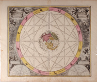
Clique nas imagens para aumentar. MERCATOR - HONDIUS - LE CLERC - CARTHOGRAPHY 16th/17th Cent. - WORLD MAPORBIS TERRAE NOVISSIMA DESCRIPTIO. Authore Gerardo Mercator, nuperimè verò iuxta recentiores Cosmographos aucta et recognita. I. Hondius sculp. I. de Clerc excu. 1633. Dim: 34x51,5 cm (Frame: 50x65 cm). Copper engraving. Framed in a modern gilt wooden frame. Contemporary fine old coloring according to the previous edition of 1603. Rare double hemisphere World map, engraved by Jodocus Hondius [Joost van Hondt] for the Parisian publisher Jean Le Clerc, based in the original plates of Mercator"s 16th Century edition. The upper corners include circles showing the wind names in Italian; the geographical directions in Dutch; an armilary spherae, or astronomical sphere, and compass rose are also included with two puti at the center. The lower corners have circular diagrams showing the phases of the moon and the climatic zones. A cartouche with the Mercator"s authorship stands at the center. A panel at the bottom contains a quote from the psalms in capital letters, which was one of Hondius" favorites [Domini est terra, et plenitudo eius, etc]. On the verso of the print there is a French text page of the Atlas from which this folium is coming from, with the title «Descrition de la Carte Universelle» and the description of the six parts or regions the men of this period thought the World was divided in: Europe, Asie, Afrique, La Mexicane, La Perouane; et La Sixieme (Terre Australis which included the Salomon Islands; the Indonesian Islands; and a large territory stretching from Terra Australis itself). The perfectly recognisable form of the Australian west coast suggests that Europeans already knew Australia since mid-16th century. Another interesting element is the representation of New Guinea, immediately below the Equator in the western hemisphere. Here both Mercator and Hondius show a perfectly recognisable north coast, with all the known places dully named, but the unknown south coast is nothing but speculation. This is one of the earliest World Maps with a wonderful large unknown southern continent. A narrow passage between South America to the unknown continent Terra Australis (a sum of Antartica and Australia), and an early cartography of Japan, Southeast Asia, and the Pacific Ocean. Along the NW Coast of America stands California in its actual position and geographical shape. About the authors: Gerard Mercator (1512-1594) is a unique figure in the history of cartography. His calculations and maps redefined the concept of cartography in the 16th century and was the first to break away from the Ptolemy model. Many of his measuring systems are still in use today, as for instance the Mercator Projection. Henricus Hondius e Jan Jansson acquired his plates and brought Mercator back to his place of outstanding cartographer of his time. Jodocus Hondius or Joost de Hondt (1563-1612) was an important Dutch cartographer, active from the end of the 16th century to the beginning of the 17th century. He is known for his maps of the New World and Europe, for re-establishing the reputation of Gerard Mercator’s work and for his portraits of Francis Drake. Jean Le Clerc (1560-1621) was a French bookseller, engraver and editor active in Paris at the end of the 16th century until the beginning of the 17th. Le Clerc ordered from the cartographer Jodocus Hondius a world map and several maps of the different continents to add to later editions of the Atlas.
Referência: 1601AD011
Local: SdC -1 Indisponível Caixa de sugestões A sua opinião é importante para nós. Se encontrou um preço incorrecto, um erro ou um problema técnico nesta página, por favor avise-nos. 
Outras Sugestões
|
Pesquisa Simples


|
|||||||
 |
||||||||
|
 English