Home |
Temáticas |
Catálogos |
Pedidos |
| |
|||||||
|

|
RUGENDAS. (Johann Moritz) HABITANTE DE GOYAS, QUADRO A ÓLEO PINTADO SOBRE MADEIRA. |
|
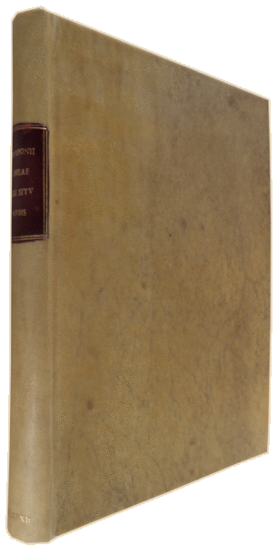
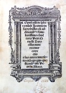
Clique nas imagens para aumentar. POMPONII MELAE. DE SITU ORBIS LIBRI TRES.An D. Schottvs Antuerpianus recensuit, & Spicilegio illustravit. Additae Hermolai Barbari Veneti, & Fredenandi Nonij Pintiani Castigationes. Antverpiae, Ex officina Christophori Plantini. M. D. LXXXII [1582]. Junto com / Together with: GEOGRAPHICA ET HISTORICA HERODOTI, Quae Latinè Mela excripsit [pacallilous] concinnata, Ab An d. schotto Antverpiano Graecarum literarum in Academia Toletana doctore. Antverpiae, Ex officina Christophori Plantini. M. D. LXXXII. [1582]. 2 volumes encadernados em 1 volume. In 4º (20,5x14,5 cm). Col: 64, [16], 80, [1 map (of 3??) ], 70, [1 bl.], 28 pags. Encadernação recente em pergaminho rígido ao gosto da época com rótulo vermelho na lombada. Ilustrado com um mapa [de 3 ?] desdobrável da autoria de Ortelius: « Orbis terrarum hunc tÿpum, secundum Pomponii Melae | traditionem delineabat Ab[raam] Ortelius 1582» (26x18 cm). Sabin não refere obra e não refere mapa. Obra contém o mais antigo texto geográfico conhecido escrito em latim. Obra clássica muito reeditada: foi impressa pela primeira vez em 1471, com oito edições incunabulares subsequentes, enquanto que até 1530 houve praticamente uma nova edição a cada dois anos. Obra de importância para a compreensão do mundo Renascentista. Embora nesta obra o autor se ter essencialmente preocupado com o mundo tal como era conhecido pelos gregos e romano, também abrangeu partes de África e um conhecimento da Índia. Esta edição não é referida por Sabin. Tem um mapa dobrável que é uma interpretação de Abraão Ortelius do mundo descrito por Pomponio Mela, intercalado em uma página desdobrável hors-text, com o título: «Orbis terrarum hunc tÿpum, secundum Pomponii Melae | traditionem delineabat Ab [raam] Ortelius 1582» (26x18 cm). Possivelmente, faltando dois mapas adicionais neste exemplar.
This edition is not refered by Sabin. It is 2 volumes bound in one volume with a folding map [of 3 maps??] which is an interpretation of Abraam Ortelius of the world described by Pomponio Mela. It is interspersed in a folding page hors-text with the title «Orbis terrarum hunc tÿpum, secundum Pomponii Melae | traditionem delineabat Ab[raam] Ortelius 1582» (26x18 cm). Possibly missing 2 maps in this copy. Voet, Plantin Press 2083 BM (STC Dutch, file) 131 BN Paris 140465 BNP Res 4228V Referência: 1502JC024
Local: M-9-A-41 Indisponível Caixa de sugestões A sua opinião é importante para nós. Se encontrou um preço incorrecto, um erro ou um problema técnico nesta página, por favor avise-nos. 
Outras Sugestões
|
Pesquisa Simples


|
|||||||
 |
||||||||
|
 English
 This is the oldest surviving geographical text written in Latin. It enjoyed readership for centuries in manuscript and was first printed in 1471 with eight subsequent incunabula editions, while in the 16th century to 1530 there was virtually a new edition every other year. It was a book of interest and importance for understanding the Renaissance world. Although Mela's work is solely concerned with the world as known by Greeks and Romans, one should remember that their world did encompass portions of Africa and a knowledge of India.