
Home |
Temáticas |
Catálogos |
Pedidos |
| |
|||||||
|

|
RUGENDAS. (Johann Moritz) HABITANTE DE GOYAS, QUADRO A ÓLEO PINTADO SOBRE MADEIRA. |
|
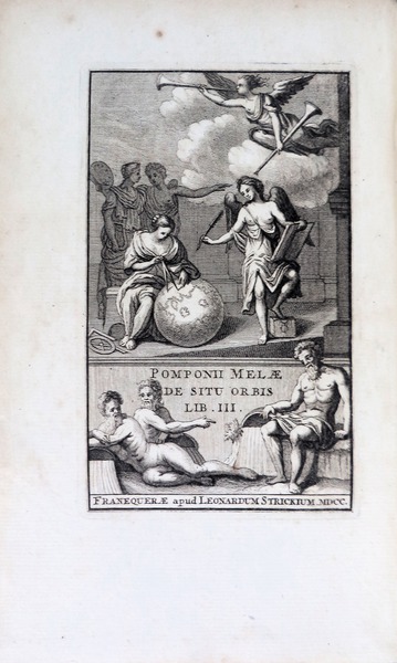
Clique nas imagens para aumentar. POMPONII MELAE. POMPONII MELAE LIBRI TRES DE SITU ORBISCum Observationibus Isaaci Vossii. Accedund ejusdem Vossii observationum ad Pomponium Melam appendix & tres indices. Editio Secunda, In qua observationes textui subjectae sunt, quae in prima editione in sine operis apparebant. Franekerae, Apud LEONARDUM STRICKIUM, Bibliopolam. M D C C. [1700]. [Colofon]: FRANEQUERAE, Ex Officina Typographica ARNOLDI IELMERI. MDCC [Franecker, Holland, 1700]. In 4º (19x11 cm). Col: [xvi], 419, [lxi], 70, [ii bl]. Encadernação da época em pergaminho rígido com ferros a seco nas esquadrias das pastas e super-libris decorativo a seco em amabas as pastas. Ilustrado com uma gravura alegórica aberta a chapa no anterrosto e com 8 gravuras intercaladas em extratexto. Exemplar com título de posse da época na folha de guarda e com ex-libris de Hugh Cecil Earl of Lonsdale. Obra contém o mais antigo texto geográfico conhecido escrito em latim. Obra clássica muito reeditada: foi impressa pela primeira vez em 1471, com oito edições incunabulares subsequentes, enquanto que até 1530 houve praticamente uma nova edição a cada dois anos. Obra de importância para a compreensão do mundo Renascentista. Embora o trabalho Mela 'apesar do autor se ter essencialmente preocupado com o mundo tal como era conhecido pelos gregos e romano, também abrangeu partes de África e um conhecimento da Índia”. Esta edição não é referida por Sabin. Tem um mapa dobrável que é uma interpretação de Abraão Orteluis do mundo descrito por Pomponio Mela, intercalado em uma página desdobrável hors-text: «Orbis terrarum hunc tÿpum, secundum Pomponii Melae | traditionem delineabat Ab [raam] Ortelius 1582» (26x18 cm). Possivelmente, faltando dois mapas adicionais neste exemplar.
Binding: beautiful contemporary hard parchment, artistically blind tooled at both folders. Red label gilt at spine. Armorial bookplate from the Earl of Lonsdale. Later edition of Mela"s geography, after many earlier editions dating back to 1471. This edition is the second to include observations by Vossius [pages not mentioned at Palau]. The first was printed at The Hague in 1658. This text includes American references, which first appeared in the 1498 Salamanca edition. Mela"s work is the only formal treatise on the subject, written in classical Latin by the first Roman geographer. Mela divides the earth into five sections, two of which he deems uninhabitable, and declares the existence of 'antichthones' (see page 7 with graphic map) which inhabit the southern zone. The climate of which would prove unbearable for the population of the northern regions. Palau 160099: «front. 8 fols, 419 pags con com 8 láms». European Americana 700/188. Schweiger II, S. 610 Referência: 1402NM001
Local: M-11-C-62 Caixa de sugestões A sua opinião é importante para nós. Se encontrou um preço incorrecto, um erro ou um problema técnico nesta página, por favor avise-nos. 
Outras Sugestões
|
Pesquisa Simples


|
|||||||
 |
||||||||
|
 English
 Work on the goegraphy of Pomponio Mela illustrated with 1 engraved frontis and 8 plates depicting graphically the thought of the author.