
Home |
Temáticas |
Catálogos |
Pedidos |
| |
|||||||
|

|
RUGENDAS. (Johann Moritz) HABITANTE DE GOYAS, QUADRO A ÓLEO PINTADO SOBRE MADEIRA. |
|
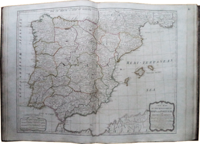
Clique nas imagens para aumentar. KITCHIN’S GENERAL ATLAS, DESCRIBING THE WHOLE UNIVERSE.BEING A COMPLETE COLLECTION OF THE MOST APPROVED MAPS EXTANT: CORRECTED WITH GREAT CARE, AND AUGMENTED FROM THE LAST EDITION OF D’ANVILLE AND ROBERT, WITH MANY IMPROVEMENTS BY OTHER EMINENT GEOGRAPHERS. ENGRAVED ON SIXTY-SEVEN PLATES, COMPRISING FORTY-ONE MAPS, AS FOLLOW: 1, 2. A General Map of the World, in Two Hemispheres, with the Tracks and all the New Discoveries of Cap. James Cook, and other Circumnavigators; with Marginal Delineations of the most interesting Particulars in the Solar, Starry, and Mundane System; to which have been later added, the Tracks of Vancouver and Perouse. 3, 4. Europe, divided into its Kingdoms, States, Republics, &c. with descriptive Tables, and many Additions and Improvements. 5, 6. England and Wales, drawn from the most accurate Surveys, by Rocque. 7, 8. Scotland, and North Britain, compiled from the best Surveys, and regulated by the latest Observations. 9, 10. Ireland, with all its Divisions, Post Roads, and Canals. 11. The Netherlands, or Ten Provinces. 12. The Seven United Provinces , with the Canals or Great Roads. 13. France, divided into Provinces, with the Post Roads. 14. New Map of France, in Eighty-three Departments. 15. Spain and Portugal, from the latest Observations. 16. Italy, with the Islands of Sicily, Sardinia, &c. 17. The Island of Corsica. 18. Germany, divided into its Circles. 19, 20. The Empire of Germany, with the kingdom of Prussia, &c. On Four Sheets. 21. Switzerland, divided into the Thirteen Cantons, &c. 22. The Northern States, comprehending the Kingdoms of Sweden, Denmark, and Norway. 23. A New Map of Sweden Proper, Gothland, &c. 24. The Kingdom of Poland, with its dismembered Provinces, &c. 25. Hungary, with the Principality of Transylvania, Sclavonia, Croatia, &c. 26. Turkey in Europe, with all its provinces and adjacent Countries. 27. The whole Russian Empire, both in Europe and Asia. 28, 29, 30. Asia, and Islands, divided into its Empires, Kingdoms, States, Regions, &c. to which were later added Two additional Sheets, extending to the South Extremity of New Holland, with the Tracks and Discoveries of Vancouver, Perouse, &c. 31. Turkey in Asia, by Mons. D’Anville. 32, 33. The East Indies, with the European Settlements, and the High Roads, &c. by Thomas Jefferys. 34. 35. Africa, which its States, Kingdoms, Republics, Regions, Islands, &c., also an Historical Description, and a Chart of the Gold Coast. 36, 37. The whole Continent of America, divided into North and South, and West-Indies. 38, 39. North America, with the West-India Islands, divided according to the Preliminary Articles of Peace, signed at Versailles, 20th Jan, 1783, wherein are particularly distinguished the United States. 40, 41. South America, with several Improvements and Additions, a Charts of Falkland’s Islands, &c. &c. L & W. LONDON: PRINTED AND PUBLISHED BY ROBERT LAURIE AND JAMES WHITTLE, 1808. In folio (de 53x39,5 cm). Encadernação da época com lombada e cantos em pele. Lombada em marroquim vermelho com nervos e ferros a ouro. Atlas ilustrado com 28 mapas desdobráveis coloridos (numerados em 41 partes) e montados em 67 folios. A maior parte dos mapas apresentam magníficas cartelas decoradas. Folha de rosto impressa com a vinheta do impressor “LW. O Atlas encontra-se impresso em fólio máximo, com os mapas mais pequenos em página dupla num único fólio. Alguns mapas estão impressos em papel de dimensões maiores, com cada folha a medir cerca de 64x72 cm, sendo assim alguns dos mapas de folha única, desdobráveis. Os mapas têm orientação vertical e horizontal, existindo por isso uma grande variedade de dimensões. Exemplar em magnífico estado de conservação. As pastas marmoreadas estão muito desgastadas e a lombada rachada, lascada e restaurada na cabeça e no pé. Um magnífico atlas mundial com um mapa de 6 folhas e onze mapas de 4 folhas. Rara edição revista e aumentada de um atlas mundial inglês. Onze dos mapas são compostos por 4 folhas cada, cada uma numerada e encadernada em 2 partes, e o mapa da Ásia com as ilhas do Oceano Índico, Arábia, Índias Orientais, Austrália e Sudoeste do Pacífico é composto por 6 folhas numeradas e encadernadas em 3 partes. Os mapas de 4 folhas incluem o mundo em 2 hemisférios, a Europa, Inglaterra e País de Gales, Escócia, Irlanda, o Sacro Império Romano, as Índias Orientais, África, América do Norte e América do Sul. O extraordinário mapa-múndi em 4 folhas de Samuel Dunn, com as rotas de várias viagens de descoberta (o mapa principal segundo D"Anville), inclui um mapa inserido em projeção Mercator, hemisférios celestes, o sistema solar (com órbitas de cometas) e até um mapa da lua, daí a referência do título do atlas a 'todo o universo'. Thomas Kitchin publica pela primeira vez em 1773 o seu Atlas com o título “A general atlas describing the whole universe”, que na altura era apenascomposto por 25 mapas. Dez anos após a sua morte, em 1794, foi revisto e aumentado, sendo publicado com o presente título em todas as edições a partir de 1796. Os mapas desta edição, rara e completa, têm datas compreendidas entre 1773 e 1808 e estão assinados por diversos cartógrafos famosos, incluindo o mapa da Europa assinado pelo próprio Kitchin. Thomas Kitchin (1718-1784) foi cartógrafo, hidrógrafo e gravador do rei George III de Inglaterra. Esta obra pesa mais de 5 Kg. e está sujeita a custos de porte adicionais.
Binding: half calf, Red morocco spine with raised bands and gilt tools. Atlas illustrated with 28 coloured folded maps (numbered in 41 parts) and assembled in 67 folios. Most of the maps present magnificent decorated cartouches. Front page with printer’s device “LW”. The Atlas is printed in Imperial folio with smaller maps on double page in a single folio. Some maps are printed on paper with bigger dimensions, with each leaf measuring around 64x72 cm, thus with some single maps also folded. The maps are printed both on portrait or landscape, hence the great variety of dimensions. Copy in very good condition. The marbled sides are badly rubbed and the spine cracked, chipped, and restored at the head and foot. A magnificent world atlas with one 6-sheet and eleven 4-sheet maps. Rare revised and enlarged edition of an English world atlas. Eleven of the maps are made from 4 sheets each, each numbered and bound in 2 parts, and the map of Asia with the islands of the Indian Ocean, Arabia, the East Indies, Australia and the Southwest Pacific is made from 6 sheets numbered and bound as 3 parts. The 4-sheet maps include the world in 2 hemispheres, Europe, England & Wales, Scotland, Ireland, the Holy Roman Empire, the East Indies, Africa, North America and South America. The extraordinary 4-sheet map of the world by Samuel Dunn, with the routes of various voyages of discovery (the main map after D"Anville), includes an inset map in Mercator projection, celestial hemispheres, the solar system (with orbits of comets) and even a map of the moon, hence the atlas title"s reference to 'the whole universe'. Thomas Kitchin publishes in 1773 his first Atlas under the title “A general atlas describing the whole universe”, which at the time only presented 25 maps. Ten years after his death in 1794, it was reviewed and augmented having been published with the present title in all editions after 1796. The maps in this very rare and complete edition are dated between 1773 and 1808, being signed by famous cartographers, including the map of Europe signed by Kitchin himself. Thomas Kitchin (1718-1784) was cartographer, hydrographer and engraver to King George III of England. This work weighs more than 5 kg. and is subject to additional shipping costs. Referências/References: Phillips & Le Gear 6027 (one 4-sheet map lacking & another incomplete). WorldCat (3 copies). Referência: 1312CS037
Local: M-17-TOP-3 Caixa de sugestões A sua opinião é importante para nós. Se encontrou um preço incorrecto, um erro ou um problema técnico nesta página, por favor avise-nos. 
Outras Sugestões
|
Pesquisa Simples


|
|||||||
 |
||||||||
|
 English
 In folio (de 53x39,5 cm).