Home |
Temáticas |
Catálogos |
Pedidos |
| |
|||||||
|

|
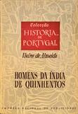
RUGENDAS. (Johann Moritz) HABITANTE DE GOYAS, QUADRO A ÓLEO PINTADO SOBRE MADEIRA. |
|
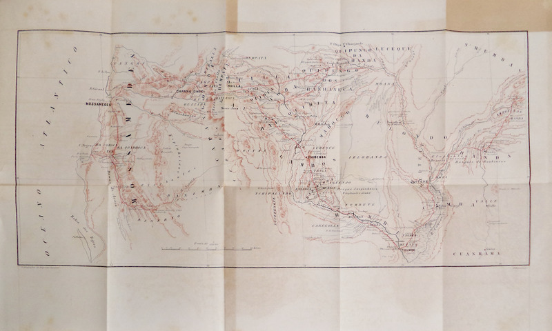
Clique nas imagens para aumentar. BRITO CAPELO. (Hermenegildo Carlos de) e Roberto Ivens. DE ANGOLA À CONTRA-COSTA. [ENC. EDITOR]Descripção de uma viagem atravez do CONTINENTE AFRICANO comprehendendo narrativas diversas, aventuras e importantes descobertas entre as quaes figuram a das origens do Lualaba, caminho entre as duas costas, visita ás terras da Garanganja, Katanga e ao curso do Luapula, bem como a descida do Zambeze, do Choa ao oceano. Por H. Capello - R. Ivens Officiaes da Armada Real Portugueza. Edição illustrada com mappas e gravuras. Volume I [Volume II]. Imprensa Nacional. Lisboa. 1886. 2 Volumes in 8.º de 24x17 cm. Com xxvii, 448; xiii, 490 págs. Encadernações editoriais em tela encerada a cinzento, com belas estampagens, a preto e a vermelho, com palmeiras e elefantes nas pastas anteriores e incluindo o retrato dos autores nas pastas posteriores. Ilustrados com desenhos no texto, 14 gravuras extratexto (4 no primeiro volume e 10 no segundo), uma das quais de página dupla, 2 desdobráveis com diagramas de curvas meteorológicas e 6 mapas desdobráveis (4 no primeiro volume e 2 no segundo). Exemplar em magnífico estado de conservação. Primeira edição, dedicada a Dom Luís I, ao Povo Português e a Manuel Pinheiro Chagas, com prefácio dos autores. Relato fundamental da grande expedição de Capelo e Ivens (1884-1885), esta obra monumental documenta a travessia científica e cartográfica entre Angola e Moçambique, consolidando a presença portuguesa no interior de África e servindo de base ao célebre Mapa Cor-de-Rosa, marco geopolítico do fim do século XIX. Páginas em numeração romana do primeiro volume com dedicatórias, quadro com a relação dos indivíduos perdidos durante a expedição ao interior de África, índice das gravuras e dos capítulos, e prefácio. Segundo volume com índice das gravuras e dos capítulos nas páginas preliminares; e índice geográfico, antroponímico e das matérias dos volumes nas páginas finais. A obra divide-se em 30 capítulos, primeiro volume do Capítulo I ao XVI (1-16), segundo do Capítulo XVII ao XXX (17-30). Em 19 de Abril de 1883, o então Ministro da Marinha e do Ultramar, Manuel Pinheiro Chagas, decretou a criação de uma Comissão de Cartografia com o objectivo de elaborar um atlas geral das colónias portuguesas. Paralelamente, visava-se o estabelecimento de uma rota comercial terrestre entre Angola e Moçambique. Como os territórios a atravessar eram ainda desconhecidos e careciam de levantamento cartográfico, recorreu-se a oficiais da Marinha, experientes em missões de exploração, capazes de avançar com maior rapidez através da aplicação dos princípios da navegação marítima ao interior africano. A abertura desta ligação terrestre representava também uma reivindicação tácita de soberania sobre as terras situadas entre as duas colónias, que correspondem atualmente aos territórios da Zâmbia, Zimbabué e Malawi. Esta pretensão ficou conhecida como o 'Mapa cor-de-rosa', ideia frequentemente atribuída ao então Ministro dos Negócios Estrangeiros, Henrique de Barros Gomes, embora este nunca o tenha assumido publicamente. O projeto colidia diretamente com os interesses britânicos de ligar o Cairo à Cidade do Cabo, originando um grave conflito diplomático entre Portugal e o Reino Unido, que culminou no Ultimato Britânico de 1890. A cedência portuguesa à pressão britânica provocou sérios danos na imagem do regime monárquico português. Numa fase inicial, a exploração decorreu entre a costa e o planalto da Huíla, prosseguindo depois pelo interior do continente até Quelimane, em Moçambique. Durante esta travessia, os exploradores continuaram os seus estudos hidrográficos, realizando também registos de carácter geográfico-natural, etnográfico e linguístico. Foi assim estabelecida a tão ambicionada ligação terrestre entre as costas de Angola e Moçambique, com a exploração das vastas regiões do interior entre os dois territórios, descritas detalhadamente nesta obra. A missão teve início a 6 de Janeiro de 1884 e terminou a 20 de Setembro de 1885, data em que os exploradores regressaram a Lisboa, sendo recebidos em triunfo pelo rei D. Luís. Hermenegildo Carlos de Brito Capelo (Palmela, 1839 — Lisboa, 1917), foi oficial da marinha portuguesa e explorador do continente africano durante o último quartel do século XIX. Em 1860 embarcou como guarda-marinha para Angola a bordo da corveta D. Estefânia, comandada pelo príncipe D. Luís, em 1863 regressa a Lisboa e é aprovado Segundo Tenente. Em 1874 torna-se Primeiro Tenente, Capitão Tenente supranumerário em 1877, e Capitão de Fragata em 1884. Ajudante de Campo Honorario de Sua Magestade El-Rei, comendador da ordem de S. Thiago. Em resultado de uma outra exploração científica em África, também com Roberto Ivens, escreveu e publicou: De Benguella ás Terras de Iácca. Lisboa, na Imp. Nacional, 1881. Roberto Ivens (São Pedro, Ponta Delgada, 1850 — Dafundo, Oeiras, 1898), filho de pai inglês e de mãe açoriana, foi um oficial da Armada, administrador colonial e explorador do continente africano, português. Concluiu o curso de Marinha em 1870 com as mais elevadas classificações, no ano seguinte frequentou a Escola Prática de Artilharia Naval, partindo em setembro para a Índia, pelo Canal do Suez, integrado na guarnição da corveta Estefânia, onde é feito guarda-marinha. A partir de 1872 inicia contactos regulares com o continente africano, ascende a diversos cargos e termina a sua carreia como Oficial.
Illustrated with drawings in text, 14 engravings hors-texte (4 in the first volume and 10 in the second), one of which is a double-page foldout, 2 leaflets with diagrams of meteorological curves and 6 leaflet maps (4 in the first volume and 2 in the second). Copy in pristine condition. First edition, dedicated to Dom Luís I, the Portuguese People and Manuel Pinheiro Chagas, with a preface by the authors. A fundamental account of the great Capelo and Ivens expedition (1884-1885), this monumental work documents the scientific and cartographic journey between Angola and Mozambique, consolidating the Portuguese presence in the interior of Africa and serving as the basis for the famous Pink Map (also known as Rose-Coloured Map), a geopolitical landmark of the late 19th century. Roman-numbered pages of the first volume with dedications, a table listing the individuals lost during the expedition to the interior of Africa, an index of the engravings and chapters, and a preface. Second volume with an index of the engravings and chapters on the preliminary pages; and a geographical, anthroponymic and subject index of the volumes on the final pages. The work is divided into 30 chapters, the first volume from Chapter I to XVI (1-16), the second from Chapter XVII to XXX (17-30). On 19 April 1883, the acting Minister for the Navy and Overseas Territories, Manuel Pinheiro Chagas, decreed the creation of a Cartography Commission with the aim of drawing up a general atlas of the Portuguese colonies. At the same time, the aim was to establish an overland trade route between Angola and Mozambique. As the territories to be crossed were still unknown and lacked a cartographic survey, recourse was made to naval officers, experienced in exploration missions, who were able to make faster progress by applying the principles of maritime navigation to the African interior. The opening of this land link also represented a tacit claim to sovereignty over the lands situated between the two colonies, which today correspond to the territories of Zambia, Zimbabwe and Malawi. This claim became known as the 'Pink Map', an idea often attributed to the Minister of Foreign Affairs, Henrique de Barros Gomes, although he never publicly recognised it. The project directly conflicted with British interests in linking Cairo to Cape Town, leading to a serious diplomatic conflict between Portugal and the United Kingdom, which culminated in the British Ultimatum of 1890. Portugal's yielding to British pressure caused serious damage to the image of the Portuguese monarchy. In an initial phase, the exploration took place between the coast and the Huíla plateau, then continued inland to Quelimane, in Mozambique. During this journey, the explorers continued their hydrographic studies and also made geographical, natural, ethnographic and linguistic records. Thus was established the long-awaited land link between the coasts of Angola and Mozambique, with the exploration of the vast inland regions between the two territories, described in detail in this book. The mission began on 6 January 1884 and ended on 20 September 1885, when the explorers returned to Lisbon and were received in triumph by King Luís. Hermenegildo Carlos de Brito Capelo (Palmela, 1839 - Lisbon, 1917) was a Portuguese naval officer and explorer of the African continent during the last quarter of the 19th century. In 1860 he embarked as a marine guard for Angola aboard the corvette D. Estefânia, commanded by Prince Luís. In 1863 he returned to Lisbon and was promoted to the rank of Second Lieutenant. In 1874 he became First Lieutenant, Captain Lieutenant supernumerary in 1877, and Frigate Captain in 1884. Honorary Aide-de-Camp to His Majesty the King, Commander of the Order of S. Thiago. As a result of another scientific exploration in Africa, also with Roberto Ivens, he wrote and published: De Benguella ás Terras de Iácca. Lisboa, Imp. Nacional, 1881. Roberto Ivens (São Pedro, Ponta Delgada, 1850 - Dafundo, Oeiras, 1898), son of an English father and Azorean mother, was a Portuguese naval officer, colonial administrator and explorer of the African continent. He graduated from the Navy in 1870 with the highest marks. The following year he attended the Practical School of Naval Artillery, leaving in September for India, via the Suez Canal, as part of the garrison of the corvette Estefânia, where he was made a marine guard. From 1872 onwards, he began regular contacts with the African continent, rose to various positions and ended his career as an officer. Referências/References: Inocêncio XI, 261-262; XVIII, 352. Referência: 1104CS001
Local: M-15-B-37 Caixa de sugestões A sua opinião é importante para nós. Se encontrou um preço incorrecto, um erro ou um problema técnico nesta página, por favor avise-nos. 
Outras Sugestões
|
Pesquisa Simples


|
|||||||
 |
||||||||
|
 English
 2 Volumes. in octavo. 24x17 cm. xxvii, 448; xiii, 490 pp. Bound in grey waxed canvas, with beautiful black and red embossings of palm trees and elephants on the front covers and including the authors' portraits on the back covers.